Furys Ferry Bridge
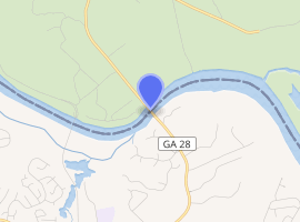
The Furys Ferry Bridge is a bridge over the Savannah River along the McCormick–Columbia county line northwest of Martinez, along the South Carolina–Georgia state line. It carries South Carolina Highway 28 and SR 28, both of which are known as Furys Ferry Road.
Furys Ferry Bridge | |
|---|---|
| Coordinates | 33°35′34.00″N 82°07′24.00″W |
| Carries | |
| Crosses | Savannah River |
| Locale | South Carolina–Georgia state line northwest of Martinez |
| Maintained by | GDOT |
| ID number | 558616 |
| Characteristics | |
| Design | Steel continuous |
| Material | Stringer/Multi-beam or Girder |
| Total length | 573.3 metres (1,881 ft) |
| Width | 13.4 metres (44 ft) |
| No. of spans | 6 (in main structure); 51 (in approach) |
| Clearance above | 5.2 metres (17 ft) |
| History | |
| Construction end | 1929 |
| Statistics | |
| Daily traffic | 3900 |
| |
| References | |
| [1] | |
History
Prior to the construction of the bridge, the area where Fury's Ferry Bridge is located used to be a Ferry Station called Fury's Ferry. The ferry was manual labor at first, which required a rope fastened to a pole on either side of the Savannah River pulled by a person or group of people. Peter Seymour, a deacon at Hopewell Baptist Church, was one of the manual labor operators of the flat boat that was used prior to the introduction of a motor engine flat boat. Peter, his son Peter Jr., and some of his grandchildren all operated the ferry at some point in their lives. The motor flat could be operated by a single person. When the bridge was completed, it operated as a toll bridge for 2 years. Prices were 25 cent per car and 50 cent per truck. When the cost of the bridge was recouped, the toll house was torn down and it became a public bridge.
Dimensions
See also

.svg.png)


- Central Savannah River Area
References
- Federal Highway Administration (2012). "NBI Structure Number: 003340002800100". National Bridge Inventory. Federal Highway Administration.