Frisian Water Line
The building of the Friese Waterlinie[1][2][3] started around 1580. The traject of the defenceline starts at the Zuidersea, along the river Linde until the De Blessebridge. Then the defence line goes to the north to Kuinre along Heerenveen, Terband, Gorredijk, Donkerbroek, Bakkeveen until Frieschepalen.
| Frisian Water Line | |
|---|---|
| Netherlands | |
 Zwartendijksterschans (Fort) | |
| Type | Defensive line |
| Site information | |
| Controlled by | Netherlands |
| Open to the public | Yes |
| Condition | In restoration |
| Site history | |
| Built | start 1580 |
| In use | 16th & 17th century |
| Materials | Flooded plains, earth wall forts |
| Battles/wars | Eighty Years' War |
.jpg)
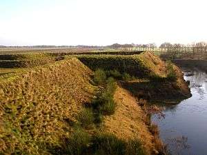
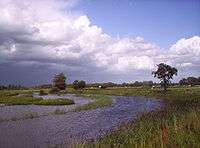
The area along the forts, dams were flooded during the Eighty Years' War against the Spanish and in 1672 Rampjaar (Disaster year) against Bernard von Galen and the French troops helping the bishop of Munster.
In the east the defence line is connected with the Groninger waterlinie which carries on to Delfzijl.
Part of the Frisian Water Line is also called the Tjonger-Lindelinie.
The ten schansen were situated in Schoterland nearby Oudehorne, just north of the river the Tjonger nearby Oudeschoot along the road to Wolvega and nearby Terbant.[4] Currently the defence line is under restoration.
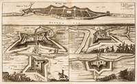
Forts along the Defence line
See also
Dutch waterlines
- Old / New Dutch Waterline
- Grebbe line
- IJssel Line
- Maas Line
- Peel-Raam Line
Other
References
- Rampjaar 1672 Archived 2007-07-07 at the Wayback Machine
- Nederlands Dagblad De friese waterlinie moet weer zichtbaar worden
- Study 2011
- "Ontdek de friesche waterlinie" (PDF) (in Dutch). Retrieved 9 November 2014.
- "Sterrenschans". Archived from the original on 2011-06-10. Retrieved 2010-04-23.
- Zwartendijksterschans