Freebridge Lynn Rural District
Freebridge Lynn Rural District was a rural district in Norfolk, England from 1894 to 1974.[1]
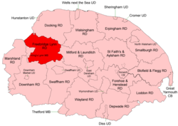
Boundaries in 1935
It was formed under the Local Government Act 1894 based on the Freebridge Lynn rural sanitary district, and was named after the Freebridge Lynn hundred. It covered an area to the east of King's Lynn.
It was reduced somewhat in 1935 when under a County Review Order, the civil parishes of Gaywood and North Lynn became part of the borough of King's Lynn.
In 1974, the district was abolished under the Local Government Act 1972, and became part of the West Norfolk district.
Parishes
| Parish | From | To | Notes |
|---|---|---|---|
| Ashwicken | 1935 | Added to Leziate | |
| Babingley | 1935 | Added to Sandringham | |
| Bawsey | |||
| Castle Acre | |||
| Castle Rising | |||
| Congham | |||
| East Walton | |||
| East Winch | |||
| Flitcham with Appleton | |||
| Gayton | |||
| Gayton Thorpe | 1935 | Added to Gayton | |
| Gaywood | 1935 | Transferred to Kings Lynn MB | |
| Great Massingham | |||
| Grimston | |||
| Harpley | |||
| Hillington | |||
| Leziate | |||
| Little Massingham | |||
| Middleton | |||
| Mintlyn | 1935 | Added to Bawsey | |
| North Lynn | 1935 | Transferred to Kings Lynn MB | |
| North Runcton | |||
| North Wootton | |||
| Pentney | |||
| Roydon | |||
| Sandringham | |||
| Setchey | 1935 | Added to West Winch | |
| South Wootton | |||
| West Acre | |||
| West Bilney | 1935 | Added to East Winch | |
| West Newton | 1935 | Added to Sandringham | |
| West Winch | |||
| Wolferton | 1935 | Added to Sandringham |
References
- "Freebridge Lynn RD through time: Census tables with data for the Local Government District". A Vision of Britain through Time. GB Historical GIS / University of Portsmouth. Retrieved 24 June 2017.
This article is issued from Wikipedia. The text is licensed under Creative Commons - Attribution - Sharealike. Additional terms may apply for the media files.