Frederick Regional Airport
Frederick Regional Airport (IATA: FDR, ICAO: KFDR, FAA LID: FDR) is a city-owned, public-use airport located three nautical miles (6 km) southeast of the central business district of Frederick, a city in Tillman County, Oklahoma, United States.[1] It was formerly known as Frederick Municipal Airport.
Frederick Regional Airport former Frederick Army Airfield | |||||||||||||||||||
|---|---|---|---|---|---|---|---|---|---|---|---|---|---|---|---|---|---|---|---|
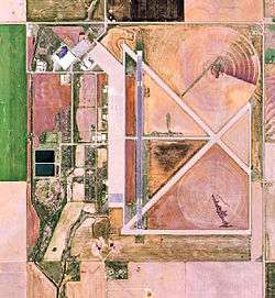 2008 USGS airphoto | |||||||||||||||||||
| Summary | |||||||||||||||||||
| Airport type | Public | ||||||||||||||||||
| Owner | City of Frederick | ||||||||||||||||||
| Serves | Frederick, Oklahoma | ||||||||||||||||||
| Elevation AMSL | 1,258 ft / 383 m | ||||||||||||||||||
| Coordinates | 34°21′08″N 098°59′02″W | ||||||||||||||||||
| Map | |||||||||||||||||||
 KFDR Location of Frederick Regional Airport | |||||||||||||||||||
| Runways | |||||||||||||||||||
| |||||||||||||||||||
| Statistics (2008) | |||||||||||||||||||
| |||||||||||||||||||

History
The airport was opened on 23 September 1942 as Frederick Army Airfield with four hard-surfaced runways, three of 6,000 foot (1,829 m) length (00/18; 04/22; 13/31) and one 4,380 feet (1,335 m) long (09/27). It was also used as a civil airport under a joint-use agreement. The airport was assigned to the United States Army Air Forces' Gulf Coast Training Center (later Central Flying Training Command) as an advanced twin-engine (level 3) pilot training airfield, with one of its instructors being comedian George Gobel. It had four local auxiliary airfields for emergency and overflow landings. Military flight operations from the airfield ceased on 31 October 1945 with the drawdown of AAFTC's pilot training program. It was then declared surplus and turned over to the Army Corps of Engineers on 21 September 1946. Eventually it was discharged to the War Assets Administration (WAA) and became a civil airport. [2] [3] [4]
Facilities and aircraft
Frederick Regional Airport covers an area of 1,442 acres (584 ha) at an elevation of 1,258 feet (383 m) above mean sea level. It has three runways: 17/35 is 6,099 by 150 feet (1,859 x 46 m) with an asphalt surface; 3/21 is 4,812 by 60 feet (1,467 x 18 m) with a concrete surface; 12/30 is 4,578 by 75 feet (1,395 x 23 m) with a concrete surface.[1]
The airport is also home to the World War II Airborne Demonstration Team Foundation, a non-profit 501(c)(3) organization located in the historic former Frederick Army Airfield portion of the airport.[5] In addition to its museum functions focused on World War II U.S. Army airborne infantry/paratrooper operations, the team also maintains two flyable C-47 Skytrain transports in one of the airport's remaining World War II military hangars. Painted in U.S. Army Air Forces markings, these aircraft are regularly flown for use in historical reenactments of paratrooper airdrop operations.[6]
For the 12-month period ending June 9, 2008, the airport had 63,700 aircraft operations, an average of 174 per day: 94% military and 6% general aviation. At that time there were 17 aircraft based at this airport: 76% single-engine, 18% multi-engine and 6% military.[1]
See also
- Oklahoma World War II Army Airfields
- 33d Flying Training Wing (World War II)
References
- FAA Airport Master Record for FDR (Form 5010 PDF). Federal Aviation Administration. Effective 8 April 2010.
-

- Shaw, Frederick J. (2004), Locating Air Force Base Sites History’s Legacy, Air Force History and Museums Program, United States Air Force, Washington DC, 2004.
- Manning, Thomas A. (2005), History of Air Education and Training Command, 1942–2002. Office of History and Research, Headquarters, AETC, Randolph AFB, Texas ASIN: B000NYX3PC
- "Archived copy". Archived from the original on 2013-06-28. Retrieved 2013-06-03.CS1 maint: archived copy as title (link)
- Team, WWII Airborne Demonstration. "WWII Airborne Demonstration Team". WWII Airborne Demonstration Team.
External links
- Aerial photo as of 8 February 1995 from USGS The National Map
- FAA Terminal Procedures for FDR, effective June 18, 2020
- Resources for this airport:
- FAA airport information for FDR
- AirNav airport information for KFDR
- ASN accident history for FDR
- FlightAware airport information and live flight tracker
- NOAA/NWS weather observations: current, past three days
- SkyVector aeronautical chart, Terminal Procedures
| Flying Training |
|  | ||||
|---|---|---|---|---|---|---|
| Technical Training |
| |||||