Fortaleza San Felipe
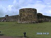
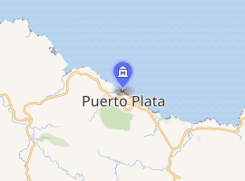
Fortaleza San Felipe is a historic Spanish fortress located in the north of Dominican Republic in the province of Puerto Plata. Is also known as El Morro de San Felipe and was used to protect the City of Puerto Plata from pirates and corsairs.[1] It is located on a hill at the Puntilla Del Malecón, overlooking the Atlantic Ocean; its strategic location protected the entrance to the city's seaport. The construction of the fort was commissioned by King Felipe II of Spain in 1564, and it was completed in 1577 by Don Rengifo de Angulo, the fort's mayor.[2]
 | |
| |
| Established | 1965 Opened to the Public in 1983 |
|---|---|
| Location | Puerto Plata, Dominican Republic |
| Coordinates | 19.8041°N 70.695925°W |
| Type | History museum |
Today, the Fortaleza San Felipe serves as a museum showcasing the important role it has played in the history of Puerto Plata, and the Dominican Republic. The Fortaleza houses military artifacts from the 18th and 19th centuries.
History
The Fort was the scene of one of the few land battles in the Quasi War, against the United States in May, 1800. The Battle of Puerto Plata Harbor saw American forces overwhelm both the French and Spanish forces.
The Fortaleza San Felipe has been used in various occasions throughout its history as a prison, it was where Pedro Santana jailed one of the founding fathers, Juan Pablo Duarte.
The Fortaleza was converted into a museum in 1965, underwent a major renovation in 1972 and in 1983 was officially opened to public.[3][4] Today, the Fortaleza is the only remnant of the 16th century in Puerto Plata, as everything else was destroyed in battles or fires during the War of Restoration.[5]
See also
| Wikimedia Commons has media related to Fortaleza de San Felipe, Puerto Plata. |
- Virtual Tour of Fortaleza San Felipe in Puerto Plata at Virtual Tour Before You Travel
References
- "Tourism Information". Embassy of the Dominican Republic. 2010. Retrieved 2010-07-25.
- "Fortaleza San Felipe: Puerto Plata". El-Bohio.com. 2010. Retrieved 2010-07-25.
- "DATOS SOBRE LA REPUBLICA DOMINICANA". Livio.com. 2005. Retrieved 2010-07-25.
- "Secretaría de Estado de Cultura". National Secretary of Cultural Affairs. 2005. Archived from the original on 2009-10-20. Retrieved 2010-07-25.
- "Historia de Puerto Plata". PuertoPlata.com.do. 2010. Retrieved 2010-07-25.