Fort Pitt Incline
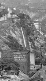
The Fort Pitt Incline was a 10 ft (3,048 mm)[1] gauge funicular railroad in the Bluff neighborhood of Pittsburgh. Opened in 1882, the incline ran from 2nd Avenue to Bluff Street, a distance of 350 feet (107 m), and a vertical distance of 135 feet (41 m).[2][3] The designer was Samuel Diescher.
.jpg)
Former incline path
| Fort Pitt Incline | |
|---|---|
 | |
| Overview | |
| Type | Funicular |
| Status | Ceased operation |
| Locale | Pittsburgh, PA |
| Coordinates | 40.4347°N 79.9892°W |
| Termini | 2nd Avenue Bluff Street |
| Stations | 2 |
| Operation | |
| Opened | 1882 |
| Closed | 1900 |
| Technical | |
| Line length | 350 feet (107 m) |
| Track gauge | 10 ft (3,048 mm) |
| Highest elevation | 135 feet (41 m) |
The incline was abandoned on 7 November 1900,[4] and afterward sat idle for about three years before fire destroyed it.[5]
Marking the former path of the incline are public steps which ascend from the south portal of the Armstrong Tunnel (at the South Tenth Street Bridge) to the Boulevard of the Allies next to the Duquesne University campus.
References
- Cable Car Lines in Pennsylvania
- "Brevities". Pittsburgh Commercial Gazette. 23 October 1882. p. 4.
- Diescher, Samuel (June 1897). "American Inclined Plane Railways". Cassier's Magazine. 12 (2): 89.
- "Tramway Tied Up". Pittsburgh Commercial Gazette. 10 November 1900. p. 8.
- "Car's Last Trip at Terrific Speed Down the Plane". The Pittsburgh Gazette. 29 July 1903. p. 1 – via Newspapers.com.

| Government |  | |
|---|---|---|
| Economy | ||
| Other topics | ||
| ||
This article is issued from Wikipedia. The text is licensed under Creative Commons - Attribution - Sharealike. Additional terms may apply for the media files.