Fort Frances–International Falls International Bridge
The Fort Frances – International Falls International Bridge is a privately owned international toll bridge connecting the towns of Fort Frances, Ontario and International Falls, Minnesota across the Rainy River.
Fort Frances–International Falls International Bridge | |
|---|---|
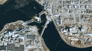 Satellite view of the bridge, on the right. A power dam is on the left. | |
| Coordinates | 48°36′26″N 93°24′07″W |
| Carries | |
| Crosses | Rainy River |
| Locale | Fort Frances, Ontario |
| Owner | Boise Inc. and Abitibi Consolidated |
| Characteristics | |
| Design | Parker Truss bridge and Half-through plate girder bridge (southbound) Concrete Girder bridge (northbound) |
| Total length | 941 feet (287 m) |
| Width | 12.5 feet (3.8 m) |
| History | |
| Opened | 1912 (1980 northbound couplet) |
| Statistics | |
| Toll | Cars/Pickups $7, Motorcycles $2, Campers $8, Semi-Trucks/Busses $16, Trailers $4, Oversized Loads $350 |

| |
The road and rail bridge was built in 1912 by the local paper company, and is still jointly owned by Boise Inc. and Resolute Forest Products, formerly Abitibi-Consolidated, which operate paper mills on the U.S. and Canadian sides of the river, respectively. A couplet for northbound vehicles was built in 1980.
The bridge toll is charged in USD on northbound traffic. Only cash is accepted. The toll rates are: $7 for cars & pickup trucks, $2 for motorcycles, $8 for campers, $16 for semi trucks and buses, $350 for trucks with oversized loads, and $4 for trailers. Discounted multi-trip swipe cards are available at the area grocery stores.[1][2] There is no toll collected on southbound trips or for pedestrian traffic.
The bridge carries both road and rail traffic, without grade separation. The rails run along the west side of the bridge, which also carries a pipeline between the paper mills. The east side of the bridge carries two lanes of automobile traffic, one in each direction. Trucks and buses are directed to drive on the rail portion of the bridge, which is capable of handling heavier loads.
A dam constructed in 1905 lies immediately west of the bridge. The reservoir to the east of the dam conceals the rapids for which International Falls was named.[3]
The bridge is the northern terminus of U.S. Route 71 and U.S. Route 53. It connects with Highway 11 and Highway 71, part of the Trans-Canada Highway, on the Ontario side.
International Crossing
Customs checkpoints are located on both ends of the bridge for road traffic"
- United States Customs and Border Protection - 2 Second Ave, International Falls, MN 56649
- Canada Border Services Agency - 101 Church Street, Fort Frances, ON P9A 3X8
References
- "Toll prices to jump slightly--for now". Times Online. June 28, 2000. Archived from the original on February 22, 2014. Retrieved February 7, 2014.
- "International Falls / Fort Frances". Ezbordercrossing.com. June 20, 2014. Retrieved February 27, 2016.
- Rainy Lake Convention & Visitors Bureau. "Things to Do". Archived from the original on January 31, 2009. Retrieved January 19, 2009.