Formigny
Formigny is a former commune in the Calvados department in the Normandy region in northwestern France. On 1 January 2017, it was merged into the new commune Formigny La Bataille.[2]
Formigny | |
|---|---|
Part of Formigny La Bataille | |
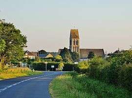 The Town of Formigny, with the church. | |
Location of Formigny 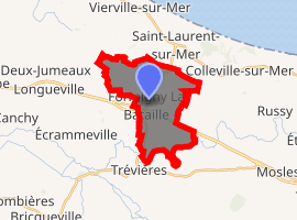
| |
 Formigny  Formigny | |
| Coordinates: 49°20′14″N 0°53′52″W | |
| Country | France |
| Region | Normandy |
| Department | Calvados |
| Arrondissement | Bayeux |
| Canton | Trévières |
| Commune | Formigny La Bataille |
| Area 1 | 10.86 km2 (4.19 sq mi) |
| Population (2017-01-01)[1] | 251 |
| • Density | 23/km2 (60/sq mi) |
| Time zone | UTC+01:00 (CET) |
| • Summer (DST) | UTC+02:00 (CEST) |
| Postal code | 14710 |
| Elevation | 2–77 m (6.6–252.6 ft) |
| 1 French Land Register data, which excludes lakes, ponds, glaciers > 1 km2 (0.386 sq mi or 247 acres) and river estuaries. | |
History
- 15 April 1450: Battle of Formigny. The battle of Formigny took place here and the French victory, marked the end of the Hundred Years War in Normandy.
- In 1823, Formigny (487 inhabitants in 1821[3]) absorbed Véret (70 inhabitants),[4] in the northwest of the territory.
- In 1858, Engranville (228 inhabitants in 1856) is divided between Formigny - most of the territory - and Trévières, in the southeast.[5]
- 8 June 1944: Formigny was liberated by elements of US 1st Infantry Division during the initial breakout from Omaha Beach.
Population
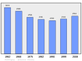
| Historical population | ||
|---|---|---|
| Year | Pop. | ±% |
| 1793 | 538 | — |
| 1800 | 338 | −37.2% |
| 1806 | 519 | +53.6% |
| 1861 | 641 | +23.5% |
| 1901 | 540 | −15.8% |
| 1962 | 324 | −40.0% |
| 1968 | 299 | −7.7% |
| 1975 | 256 | −14.4% |
| 1982 | 241 | −5.9% |
| 1990 | 233 | −3.3% |
| 1999 | 244 | +4.7% |
| 2008 | 264 | +8.2% |
 Population - Municipality
See also
References
- "Populations légales 2017". INSEE. Retrieved 6 January 2020.
- Arrêté préfectoral 8 September 2016 (in French)
- Des villages de Cassini aux communes d'aujourd'hui.
- http://cassini.ehess.fr/cassini/fr/html/fiche.php?select_resultat=14391
- Des villages de Cassini aux communes d'aujourd'hui, « Notice communale - Engranville.
External links
| Wikimedia Commons has media related to Formigny. |
- The battle of Formigny (in French)
| Authority control |
|
|---|
This article is issued from Wikipedia. The text is licensed under Creative Commons - Attribution - Sharealike. Additional terms may apply for the media files.