Florida State Road 615
State Road 615 (SR 615), locally known as 25th Street, is a 6.2-mile-long (10.0 km) north–south commuter road serving St. Lucie County, Florida. Its northern terminus is an intersection with U.S. Route 1 (US 1 or SR 5) northeast of the St. Lucie County Airport in St. Lucie Village. The SR 615 extends south along 25th Street, intersecting with Okeechobee Road (CR 770) and Virginia Avenue (SR 70) to an intersection with Edwards Road (CR 611). County Road 615 (CR 615) begins here (albeit unsigned) and extends 10.1 miles (16.3 km) south to Port St. Lucie. At Midway Road (CR 712), the designation changes from 25th Street to St. James Drive. At the southern end of St. James Drive at Airoso Boulevard, the CR 615 designation continues south on Airoso Boulevard until its southern terminus with Port St. Lucie Blvd. (SR 716), where Port St. Lucie's City Hall is located.
| ||||
|---|---|---|---|---|
| County Road 615 25th Street | ||||
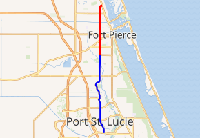
SR 615 in red, CR 615 in blue | ||||
| Route information | ||||
| Maintained by FDOT and St. Lucie County | ||||
| Length | 16.3 mi[1][2] (26.2 km) 6.168 miles (9.926 km) as SR 615[1] | |||
| Major junctions | ||||
| South end | ||||
| ||||
| North end | ||||
| Location | ||||
| Counties | St. Lucie | |||
| Highway system | ||||
| ||||


No state or county route signage exists south of Edwards Road in Fort Pierce.
Major intersections
The entire route is in St. Lucie County.
| Location | mi[1][2] | km | Destinations | Notes | |
|---|---|---|---|---|---|
| Port St. Lucie | 0.0 | 0.0 | |||
| White City | 7.6 | 12.2 | |||
| Fort Pierce South | 10.1 0.000 | 16.3 0.000 | Transition from CR 615 to SR 615 | ||
| Fort Pierce | 0.991 | 1.595 | |||
| 1.796 | 2.890 | Former routing of SR 70 | |||
| 2.496 | 4.017 | ||||
| Fort Pierce North | 5.016 | 8.072 | Termini of SR 608 and CR 608 | ||
| St. Lucie Village | 6.168 | 9.926 | Road is unsigned SR 5 | ||
1.000 mi = 1.609 km; 1.000 km = 0.621 mi
| |||||
References
- FDOT straight line diagrams Archived March 6, 2014, at the Wayback Machine, accessed March 2014
- Google (June 16, 2019). "County Road 615" (Map). Google Maps. Google. Retrieved June 16, 2019.