Florida State Road 399
State Road 399 (SR 399) is a state road in Santa Rosa County, Florida. Although it only extends 0.32 miles (0.51 km) from U.S. Route 98 (US 98) to the Bob Sikes Bridge, County Road 399 (CR 399) continues over the bridge, along Santa Rosa Island, and back to US 98 via the Navarre Bridge. Other segments of CR 399 also exist on the mainland.
| ||||
|---|---|---|---|---|
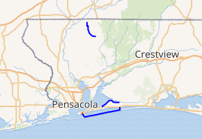
SR 399 in red, CR 399 in blue | ||||
| Route information | ||||
| Maintained by FDOT | ||||
| Length | 22.700 mi[1] (36.532 km) | |||
| Major junctions | ||||
| South end | ||||
| North end | ||||
| Location | ||||
| Counties | Santa Rosa | |||
| Highway system | ||||
| ||||

Route description
Beginning at a trumpet interchange with US 98–SR 30 in Gulf Breeze, SR 399 heads south to the end of state maintenance at the gore of the interchange. CR 399 continues south over the Bob Sikes Bridge, which crosses Santa Rosa Sound from the mainland to Santa Rosa Island. It then curves east at Pensacola Beach and heads east along the barrier island through the Gulf Islands National Seashore to Navarre Beach, where CR 399 turns north and crosses the Navarre Bridge back to the mainland. The Navarre Bridge was a toll bridge with one cash and one SunPass lane for southbound traffic until 2005 but it is now toll-free.
Major intersections
| County | Location | mi[2] | km | Destinations | Notes |
|---|---|---|---|---|---|
| Santa Rosa | Gulf Breeze | 0.000 | 0.000 | interchange | |
| 0.319[1] | 0.513 | south end of state maintenance | |||
| Santa Rosa Sound | 0.6– 1.3 | 0.97– 2.1 | Bob Sikes Bridge | ||
| Escambia | Pensacola Beach | 1.5 | 2.4 | toll plaza (southbound only) | |
| 2.2 | 3.5 | Fort Pickens Road | to Fort Pickens | ||
| Santa Rosa | Navarre Beach | 19.3 | 31.1 | Navarre Beach Park | |
| | 20.1– 20.6 | 32.3– 33.2 | Navarre Bridge over Santa Rosa Sound | ||
| Navarre | 20.7 | 33.3 | |||
| 1.000 mi = 1.609 km; 1.000 km = 0.621 mi | |||||
References
- FDOT straight line diagrams Archived March 6, 2014, at the Wayback Machine, accessed April 2014
- Google Maps distance
External links
