Fiora (river)
The Fiora is a river in northern Lazio and southern Tuscany, which springs from the southern flank of the Monte Amiata, near Santa Fiora. After crossing the Lazio Maremma, it flows in the north-western part of the province of Viterbo before getting into the Tyrrhenian Sea near Montalto di Castro. One of the remarkable settlements in the Fiora River during the Bronze Age period is Crostoletto di Lamone, a plateau.
| Fiora | |
|---|---|
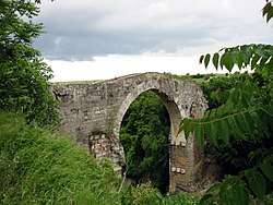 The Ponte di Badia at Vulci | |
| Location | |
| Country | Italy |
| Physical characteristics | |
| Source | |
| • location | Monte Amiata |
| • elevation | 1,200 m (3,900 ft) |
| Mouth | Tyrrhenian Sea |
• coordinates | 42.3283°N 11.5739°E |
| Length | 83 km (52 mi) |
| Basin size | 1,600 square kilometres (620 sq mi) |
This article is issued from Wikipedia. The text is licensed under Creative Commons - Attribution - Sharealike. Additional terms may apply for the media files.