Fan Bwlch Chwyth
Fan Bwlch Chwyth is a peak in the Fforest Fawr section of the Brecon Beacons National Park and within the county of Powys.
| Fan Bwlch Chwyth | |
|---|---|
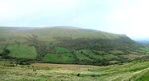 Fan Bwlch Chwyth viewed from the south | |
| Highest point | |
| Elevation | 603 m (1,978 ft) |
| Coordinates | 51°52′57″N 3°34′53″W |
| Geography | |
| Location | Powys, Wales |
| Parent range | Brecon Beacons |
| OS grid | SN912217 |
Its summit (at 603 m) is marked by a trig point at OS grid ref SN 912217.[1]
Geology
The hill is formed from sandstones and mudstones of the Senni Beds Formation and Brownstones Formation of the Old Red Sandstone laid down during the Devonian period. A north-northwest - south-southeast trending fault runs across its north-eastern face.
This face is much the steepest and has its origins in the ice ages when a minor glacier grew at this spot. It has left a couple of arcuate moraines which are readily seen from the track. The glaciated rock face has been quarried. The quarry is designated as a site of special scientific interest for its geological interest.[2]
Access
The entire hill is open country across which the walker can wander at will. A bridleway runs south-eastward from the minor road between Heol Senni and the A4067 road. The bridleway follows, in part at least, the vehicular track (no public vehicular access) to the disused quarry.
References
- Ordnance Survey Explorer map OL12 'Brecon Beacons National Park: western area'
- British Geological Survey 1:50,000 map sheet 231 'Brecon' & accompanying sheet explanation