Espinhaço Mountains
The Espinhaço Mountains (Portuguese: Serra do Espinhaço, IPA: [ˈsɛ.ʁɐ dwis.piˈɲa.su]) are a mountain range in Brazil. The range runs roughly north and south through the states of Minas Gerais and Bahia, extending for approximately 1,100 km (680 mi).[1][2][3] It forms the divide between the upper watershed of the São Francisco River and those of the shorter rivers which flow east into the Atlantic Ocean, including the Doce, the Jequitinhonha, and the Pardo rivers.[2] Pico do Sol, its highest peak, rises to 2,072 metres (6,798 ft), in Catas Altas town (Caraça National Park). The historical town of Diamantina are located in the Espinhaço Mountains. The Espinhaço Mountains were a major via through which Minas Gerais was settled during the Gold Rush of the 18th century.[1][4]
| Espinhaço Mountains | |
|---|---|
| Serra do Espinhaço (Portuguese) | |
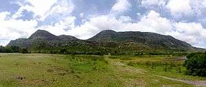 Espinhaço Mountains viewed from Lapinha da Serra | |
| Highest point | |
| Peak | Pico do Sol, Minas Gerais |
| Elevation | 2,072 m (6,798 ft) |
| Coordinates | 17°41′39.9″S 43°46′59.9″W |
| Dimensions | |
| Length | 1,100 km (680 mi) |
| Geography | |
 | |
| Country | Brazil |
| States/Provinces | Minas Gerais and Bahia |
References
- "Espinhaço Mountains". Encyclopædia Britannica. Encyclopædia Britannica Inc. 2014.
- Carvalho, Fernanda de (2014). "Relationship between physical and chemical soil attributes and plant species diversity in tropical mountain ecosystems from Brazil". Journal of Mountain Science. Kluwer Academic Publisher. 11 (4): 875–883. doi:10.1007/s11629-013-2792-4.
- Rapini, Alessandro; De Mello-Silva, Renato; Kawasaki, Maria (2002). "Richness and endemism in Asclepiadoideae (Apocynaceae) rom the Espinhaço Range of Minas Gerais, Brazil – a conservationist view". Biodiversity & Conservation. Kluwer Academic Publisher. 11 (10): 1733–1746.
- http://www.forumpatrimonio.com.br/paisagem2014/artigos/pdf/265.pdf