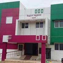
Elumalai
Elumalai is a Panchayat town in the district of Madurai, in the Indian state of Tamil Nadu. Originally named Aezhumalai (Seven Hills), the town is located near Usilampatti (18 km), Madurai (54 km), Theni (56 km) and Peraiyur (27 km) in the Western ghats.
Elumalai | |
|---|---|
Panchayat town | |
 Elumalai Location in Tamil Nadu, India | |
| Coordinates: 9.87°N 77.7°E | |
| Country | |
| State | Tamil Nadu |
| District | Madurai |
| Area | |
| • Total | 8.04 km2 (3.10 sq mi) |
| Elevation | 208 m (682 ft) |
| Population (2011) | |
| • Total | 15,746 |
| • Density | 2,000/km2 (5,100/sq mi) |
| Languages | |
| • Official | Tamil |
| Time zone | UTC+5:30 (IST) |
| Area code(s) | 04552 |
| Vehicle registration | TN-58 |
Religion
It has religious sites, including the Vasi Malayan, Sadayandi Kovil, Shri Thiruvenkatanatha Swami, Muthalamman, Badrakali Amman, Sandana Mariyamman and Maathanthira Shri Subramania temples, as well as a mosque and church.
September sees the celebration of the Vasimalayan festival. Also, every Saturday, free food is provided by the Vasimalayan Temple.
Education
The government runs a boys and girls school. A private high school operates there. The Bharathiyar Matric Higher Secondary School, Shri vishwa vidhyalaya primary school . In addition, many primary schools serve the town and surrounding villages. Thiruvalluvar Group of Institutions are Situated near by 4km in Soolapuram/Mallapuram
Demographics
As of the 2001 India census,[1] Elumalai had a population of 14,030. Males constitute 50% of the population and females 50%. 10% of the population are under 6 years of age. Elumalai has an average literacy rate of 56%, which is lower than the national average of 59.5%. Male literacy is 67% and female literacy is 45%.
Famous personalities
Tamil film personality Kalaignanam, who is a writer, director, producer, actor and lyricist was born in 1930 In Elumalai. His father was a Panchayat Board clerk.
Geography
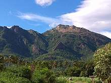
The town is surrounded by seven hills and is famous for Sathuragiri Hill close to Saptur. The Seven hills (EZhilmigu Elumalai) provide an abundant variety of flora. In addition, the Elumalai Vasimalayan mountain serves as a boundary between the Madurai and Theni districts.
Airports
- Madurai Airport (57.4 km)
- Tuticorin Airport (130 km)
- Cochin Intl Airport (150 km)
- Coimbatore Airport (225 km)
- Tiruchirappalli Airport (150 km)
References
- "Census of India 2001: Data from the 2001 Census, including cities, villages and towns (Provisional)". Census Commission of India. Archived from the original on 16 June 2004. Retrieved 1 November 2008.