Edna Fault
Edna Fault is a strike-slip fault in Edna Valley, California, known for its abrupt right angle shape when viewed from the north or south. Its cliff face faces east.
| Edna Fault | |
|---|---|
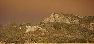 Edna Fault during Thomas Fire | |
| Highest point | |
| Coordinates | 35°11′02″N 120°36′38″W [1] |
| Geography | |
| Location | San Luis Obispo County, California, U.S. |
| Range coordinates | 35.132035°N 120.4735°W |
| Parent range | San Luis Range |
| Topo map | San Luis Obispo |
| Geology | |
| Mountain type | Strike-slip fault |
Geology
Edna Fault is part of the San Luis (Mount Buchon) range in San Luis Obispo County, California. It contains both Miocene and Pliocene strata against a Franciscan basement and forms the northern border of the Pismo syncline.[2] According to trenching and bedrock mapping studies, the fault was inactive during the late Quaternary period.[2][3]
Wildlife
Known flora and fauna of Edna Fault includes red-tailed hawk, ground squirrels, bobcats, and coast live oaks, among others.
Land use
Though many local residents have expressed interest in hiking or climbing the fault, the property is under private ownership and such activities are uncommon.
A single road owned by PG&E leads up behind the fault nearly to the edge.
References
- "Mount Buchon". Geographic Names Information System. United States Geological Survey. Retrieved 2018-06-05.
- "Water Resources of the Arroyo Grande" (PDF). Water Data Library, California Department of Water Resources. Retrieved 2018-06-05.
- "SAN SIMEON FAULT – Findings" (PDF). Pacific Gas and Electric Company. Retrieved 2018-06-05.