Edmund March Blunt
Edmund March Blunt (June 20, 1770 – January 2, 1862) was an American navigator, author, and publisher of nautical magazines.[2] He established a nautical book and chart publishing firm that became the largest publishing firm in early 19th century.[3] In 1796, he published American Coastal Pilot, which described every port of the United States. Blunt created a map in 1796 of what is now the Federated States of Micronesia.[4]
Edmund March Blunt | |
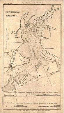
|---|---|
| Born | June 20, 1770[1] Portsmouth, New Hampshire, United States[1] |
| Died | January 2, 1862 (aged 91) Sing Sing, New York, United States |
| Occupation | Navigator, publisher, writer |
Personal life
Blunt was born in Portsmouth, New Hampshire,[1] and lived in Sing Sing, New York.[1][5] He had four sons: Nathaniel B., Edmund, George and Joseph[1]. Edmund Blunt was a hydrographer.[1] Mount Blunt in Antarctica is named for him. [6]
Nautical publisher
In 1824, his two sons, George and Edmund went into business with their father at the publishing house of marine works called E. & G. W. Blunt Publishing. Blunt published Blunt's Coastal Pilot, which became American Coast Pilot.[4][5] American Coast Pilot began publication in 1796, published in Newburyport, Massachusetts. It was published until 1858 by the United States Hydrographic Office, reaching 21 editions by 1867. Its final publication was produced in New York. (Sabin 6025).[1][5] Blunt expanded chart coverage into the Pacific Ocean and in 1857, expanded into the Indian Ocean.[3]
The firm closed in 1872 and sold the chart copyrights and plates to the Coast Survey and U.S. Navy Hydrographic Office.[3]
References
- Samuel Austin Allibone (1859). A critical dictionary of English literature, and British and American authors living and deceased. p. 211. Retrieved May 22, 2013.
- Brown, John Howard (1899). Lamb's Biographical Dictionary of the United States, Volume 1. p. 333. Retrieved August 22, 2018.
- National Ocean Survey Historical Cartobibliography II: Age of Exploration, by National Ocean Survey. Physical Science Services Branch. Cartographic Support Section
- "A New Chart of Part of the North Pacific Ocean Exhibiting the Various Straits, Islands and Dangers". World Digital Library. Retrieved May 23, 2013.
- Stephen Jenkins (1911). The greatest street in the world: the story of Broadway, old and new, from the Bowling Green to Albany. G.P. Putnam's Sons. p. 370. Retrieved May 22, 2013.
- https://geonames.usgs.gov/apex/f?p=138:3:0::NO::P3_ANTAR_ID,P3_TITLE:1562,Mount%20Blunt
| Authority control |
|
|---|