Eau Rouge
The Eau Rouge is a small, 15-kilometre (9 mi) long stream in the Belgian province of Liège, right tributary of the Amblève.
| Eau Rouge | |
|---|---|
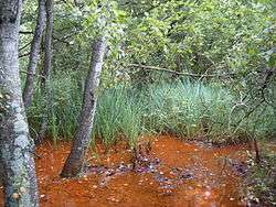 Red water (eau rouge in French) on the banks of the river | |
| Location | |
| Country | Belgium |
| Province | Liège |
| Physical characteristics | |
| Source | |
| ⁃ location | High Fens |
| Mouth | |
⁃ location | Amblève |
⁃ coordinates | 50.3948°N 5.9464°E |
| Length | 15 km (9 mi) |
| Basin features | |
| Progression | Amblève→ Ourthe→ Meuse→ North Sea |

It starts in the Hautes Fagnes ("High Fens") and ends in Challes, near Stavelot in the river Amblève. The river gets its name from the coloration of the stones and riverbed due to reddish iron oxide deposits. The Eau Rouge is particularly geomorphologically interesting, as it appears to be using the old Warche river stream bed.
The Eau Rouge has been a border river for several periods in its existence, including an administrative boundary under the Roman Empire between Cologne and Tongeren, and the state border between the Netherlands and Prussia from 1815 to 1839 and then between Belgium and Prussia from 1839 to 1919.
Eau Rouge and the F1 Circuit
The Eau Rouge has lent its name to the Eau Rouge corner, one of the best-known corners in Formula One race tracks in the Circuit de Spa-Francorchamps motor racing circuit, at the point where the track crosses it for the first time.
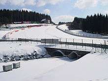 The bridge where the Circuit de Spa-Francorchamps crosses the Eau Rouge stream is located at the corner bearing its name. The right-hand turn visible in the background at the top of the hill is Raidillon.[1]
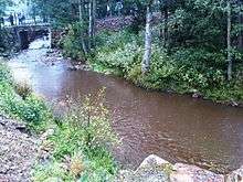 The Eau Rouge river as it passes the interior of the Circuit de Spa-Francorchamps, close to the pit complex
References
- "Eau Rouge or Raidillon? Spa's 'confusing' corner names". formula1.com. Formula One World Championship Limited. 23 August 2018. Retrieved 31 December 2019.
| Wikimedia Commons has media related to Eau Rouge. |