Driffield Street, Queenstown
Driffield Street, Queenstown is the main north to south street of Queenstown, Tasmania, Australia.
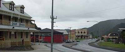
Looking south down Driffield Street, Galley Museum, Library, Empire Hotel, railway station in view
It commences at a junction with Lyell Highway,[1] and runs parallel to the railway station, railway yard and railway as far as Henry Street.[2]
It is also the location of the Galley Museum,[3] and the Queenstown Library (also known as the Robert Carl Sticht Memorial library).[4][5]
The prominent Empire Hotel is on the corner of Orr Street. It is also the location of St Martin's Hall.[6]
In the era of the operations of the Mount Lyell Mining and Railway Company it was the location of retail businesses run by the company, as well as the railway [7]
See also
Notes
- older maps would indicate Penghana Road as the western part of junction, and Batchelor Street rather than Lyell Highway see- for instance Tasmap (Agency : Tasmania) (2001), Tasmanian towns street atlas (Ed. 7 ed.), Tasmap, ISBN 978-0-7246-6257-9
- however some cartographic indicators on digital maps show Driffield street join with Conlan street – Google maps, for instance
- "West Coast "MAY NOT BE ALIVE"". The Examiner (Tasmania). XCVII (100). Tasmania, Australia. 8 July 1938. p. 3 (DAILY). Retrieved 2 April 2017 – via National Library of Australia.
- "SPRING FLOWER SHOW AT QUEENSTOWN". The Advocate. Tasmania. 19 September 1938. p. 8 (DAILY). Retrieved 2 April 2017 – via National Library of Australia.
- "GENERAL NEWS ITEMS". The Mercury. CXXIV (18, 174). Tasmania. 28 January 1926. p. 4. Retrieved 2 April 2017 – via National Library of Australia.
This article is issued from Wikipedia. The text is licensed under Creative Commons - Attribution - Sharealike. Additional terms may apply for the media files.