Drôme (Aure)
The Drôme is a 57.9 km long river in Normandy.[1] Its source is on the border of the Manche and Calvados departments, at le Grand Cauville locality, near Saint-Martin-des-Besaces[2] and joins the Aure, left bank at Maisons, downstream of Bayeux in the Bessin region. It is a sub-affluent of the Vire.
| Drôme | |
|---|---|
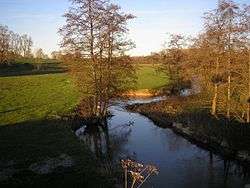 between Vidouville and La Vacquerie | |
| Location | |
| Country | France |
| Physical characteristics | |
| Source | |
| • location | Saint-Martin-des-Besaces |
| • coordinates | 49.0089°N 0.9006°W |
| • elevation | 205 m (673 ft) |
| Mouth | |
• location | Aure |
• coordinates | 49.3209°N 0.7502°W |
• elevation | 18 m (59 ft) |
| Length | 57.9 km (36.0 mi) |
| Basin size | 245 km2 (95 sq mi) |
| Discharge | |
| • average | 2.33 m3/s (82 cu ft/s) (Sully) |
| Basin features | |
| Progression | Aure→ Vire→ English Channel |
Watershed
The watershed of the Drôme neighbours those of the Vire, Aure (east), Tortonne (NW) and Seulles (SE).
It is a narrow, northward basin. The longest of its affluents is the ruisseau du Vey (7.3 km)[3]),which it joins at Cormolain.
Drôme valley

Sully bridge
- Castle (ranked monument historique[4]) and Saint-Martin de Balleroy Church (ranked[4]) at Balleroy,
- Pont de Sully (inscrit[4]) between Castillon and Vaubadon.
- Manoir du Pont-Senot (inscrit[4]) à Noron-la-Poterie.
- Église Notre-Dame de Ranchy (clocher inscrit[4]).
- Château de Barbeville (inscrit[4]).
- Castle (inscrit[4]) and Église Saint-Cyr-et-Sainte-Julitte (inscrite[4]) at Vaucelles.
- Église Notre-Dame-de-la-Nativité at Sully (inscrite[4]).
References
- Sandre database
- Les géoservices du Conseil général du Calvados - La carte dynamique |accessdate= 12 August 2010 Archived January 31, 2013, at the Wayback Machine Couches Cours d'eau BDCarthage, Communes et Communes (Libellé) activées.
- "Fiche du ruisseau du Vey sur le site du Sandre". Retrieved September 1, 2010.
- Base Mérimée
This article is issued from Wikipedia. The text is licensed under Creative Commons - Attribution - Sharealike. Additional terms may apply for the media files.