Downham Rural District
Downham Rural District was a rural district in Norfolk, England from 1894 to 1974.[1]
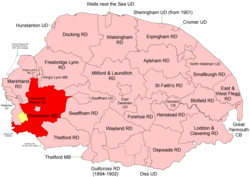 Position within Norfolk, 1894 Boundaries in 1894. 1930 extension in yellow. |
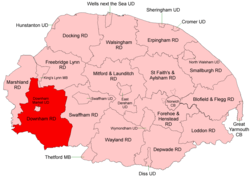 Position within Norfolk, 1935 Boundaries in 1935 |
It was formed under the Local Government Act 1894 based on the Downham rural sanitary district. It completely encircled Downham Market Urban District.
In 1930 a new parish of Nordelph was created in Downham RD, taking land mostly out of the Marshland RD parish of Upwell.[2]
Several changes were made to its boundaries in 1935. In particular, it took in four large (in area terms) parishes from the disbanded Thetford Rural District.
In 1974, the district was abolished under the Local Government Act 1972, and became part of the West Norfolk district, renamed King's Lynn and West Norfolk in 1981.
Welney Rural District
Welney Rural District[3] was (at least nominally) a short-lived entity created in 1894 containing the only parish, West Welney, which had been in Downham RSD but lay in the Isle of Ely rather than Norfolk. Its population at the time was about 500.[4] In 1895 the parish was transferred to Norfolk, and Welney RD was absorbed by Downham RD. There does not appear to be any evidence that it ever actually functioned.[5]
Statistics
| Year | Area (ha) [6] |
Population [7] |
Density (pop/ha) |
|---|---|---|---|
| 1911 | 33,156 | 15,527 | 0.47 |
| 1921 | 14,660 | 0.44 | |
| 1931 | 34,565 | 15,503 | 0.45 |
| 1951 | 50,243 | 24,496 | 0.49 |
| 1961 | 23,655 | 0.47 |
Parishes
| Parish | From | To | Notes |
|---|---|---|---|
| Barton Bendish | |||
| Bexwell | 1935 | Added to Ryston | |
| Boughton | |||
| Crimplesham | |||
| Denver | |||
| Downham West | |||
| Feltwell | 1935 | Formerly Thetford RD | |
| Fincham | |||
| Fordham | |||
| Hilgay | |||
| Hockwold cum Wilton | 1935 | Formerly Thetford RD | |
| Marham | |||
| Methwold | 1935 | Formerly Thetford RD | |
| Nordelph | 1930 | Created from parts of Denver, Downham West & Stow Bardolph and from Outwell and Upwell in Marshland RD | |
| Northwold | 1935 | Formerly Thetford RD | |
| Runcton Holme | |||
| Ryston | |||
| Ryston with Roxham | 1935 | Added to Ryston | |
| Shouldham | |||
| Shouldham Thorpe | |||
| Southery | |||
| Stoke Ferry | |||
| Stow Bardolph | |||
| Stradsett | |||
| Tottenhill | |||
| Watlington | |||
| Welney | |||
| Wereham | |||
| West Dereham | |||
| West Welney | 1895 | 1935 | Welney RD 1894-95. Added to Welney 1935 |
| Wiggenhall St Germans | As "Wiggenhall St German" before 1935 | ||
| Wiggenhall St Mary Magdalen | |||
| Wiggenhall St Mary the Virgin | |||
| Wiggenhall St Peter | 1935 | Added to Wiggenhall St Germans | |
| Wimbotsham | |||
| Wormegay | |||
| Wretton |
References
- "Downham RD through time: Census tables with data for the Local Government District". A Vision of Britain through Time. GB Historical GIS / University of Portsmouth. Retrieved 25 June 2017.
- "Upwell CP through time: Population Statistics: Area (acres)". A Vision of Britain through Time. GB Historical GIS / University of Portsmouth. Shows reduction in Upwell between 1921 & 1931. Note that several other pages on the site fail to report this transfer. Retrieved 26 June 2017.
- "Welney RD through time: Census tables with data for the Local Government District". A Vision of Britain through Time. GB Historical GIS / University of Portsmouth. Retrieved 25 June 2017.
- "West Welney CP through time: Population Statistics: Males and Females". A Vision of Britain through Time. GB Historical GIS / University of Portsmouth. Retrieved 25 June 2017.
- "Local Authority Building Plans Survey Report, Pre-1974 Authorities, England". The National Archives. Lines 241-2. Retrieved 25 June 2017.
- "Downham RD through time: Population Statistics: Area (acres)". A Vision of Britain through Time. GB Historical GIS / University of Portsmouth.
- "Downham RD through time: Population Statistics: Total Population". A Vision of Britain through Time. GB Historical GIS / University of Portsmouth.