Douglas Island
Douglas Island is a tidal island in the U.S. state of Alaska. It is part of the city and borough of Juneau, just west of downtown Juneau and east of Admiralty Island. It is separated from mainland Juneau by the Gastineau Channel, and contains the communities of Douglas and West Juneau.

History
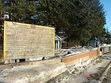
Douglas Island was named for John Douglas, Bishop of Salisbury, by Captain George Vancouver. Joseph Whidbey, master of HMS Discovery during Vancouver's expedition, was the first to sight it in 1794.[1]
.jpeg)
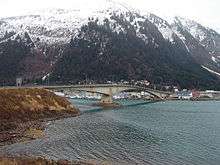
The Juneau-Douglas Bridge, connecting the island with Juneau, provides a two lane road to and from the island and accommodates both vehicular and pedestrian traffic.[2] There have been plans to build a new bridge from North Douglas to the Mendenhall Valley.
Geography
Admiralty Island lies to the west and south, across the Stephens Passage.
.jpeg)
Features of the island include remnants of the Treadwell gold mine, Sandy Beach, the only sand beach in the Juneau area (made from mine tailings), Eaglecrest Ski Area, Perseverance Theatre, and the Douglas Public Library. As a tidal island, Douglas is connected to the mainland at its north end when the Gastineau Channel is at low tide. During low tide, Douglas Island is connected with Juneau's Twin Lakes area, the Juneau International Airport as well as other sites.
Douglas is usually thought of as two areas: downtown Douglas 58°16′32″N 134°23′33″W (including West Juneau 58°17′42″N 134°25′46″W), containing Douglas Harbor, Sandy Beach, the mines, the library, Gastineau Elementary, the theatre, the gas station, the few bars and restaurants, and the bridge to Juneau; and North Douglas Island, containing a tank farm, Eaglecrest Ski Area and a heliport.
The island has a land area of 76.93 square miles (199.25 km2) and had a population of 5,297 at the 2000 United States Census, with over half of the island's population residing in Douglas proper. It is part of the City and Borough of Juneau. The island's highest point, Mount Ben Stewart, was named in honor of Benjamin D. Stewart (1878–1976), an early mayor of Juneau.
Politics
Following the 2012 election of Merrill Sanford, the incumbent mayor of Juneau, the Juneau Empire noted the island's "outsized contribution" to Juneau-area politics. Sanford, Byron Mallott (former lieutenant governor of Alaska) and Dennis Egan (currently Juneau's representative in the Alaska Senate) live in West Juneau. Sally Smith, who succeeded Egan as mayor, lives in the Lawson Creek neighborhood between Douglas and West Juneau, while her successor Bruce Botelho lives in Douglas. Beth Kerttula, who represented portions of Juneau in the Alaska House of Representatives from 1999 to 2014, lives in North Douglas.[3] Additionally, John Dimond, the first Juneau-based justice of the Alaska Supreme Court, lived in Douglas, while his successor Robert Boochever lived along the Douglas Highway a half-mile north of Douglas's then-city limits.
References
- Douglas Island: Blocks 1004 thru 1039, Block Group 1; Block Group 2; Block Group 3; Census Tract 6, Juneau City and Borough, Alaska United States Census Bureau
- "Historic Preservation in Juneau". juneau.org. Retrieved 28 April 2018.
- "Structures / Douglas Bridge / Images". Structurae. Retrieved 2011-02-18.
- Miller, Mark D. (November 15, 2012). "In Juneau politics, Douglas Island looms large". Juneau Empire. Retrieved January 20, 2015.
External links
| Wikimedia Commons has media related to Douglas Island. |
- [ Map of Douglas Island]
| Authority control |
|
|---|