Dongola Reach
The Dongola Reach is a reach of approximately 160 km in length stretching from the Fourth downriver to the Third Cataracts of the Nile in Upper Nubia, Sudan.[1] Named after the Sudanese town of Dongola which dominates this part of the river, the reach was the heart of ancient Nubia.[2]
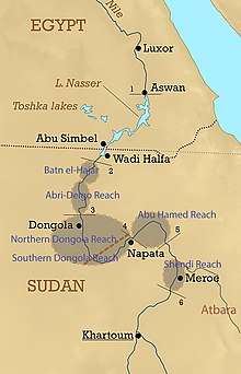
The Southern and the Northern Dongola Reach
The area where the Nile flows from the Fourth Cataract to the southwest making a great S-shaped bend following the structure of the Central African Shear Zone is the Southern Dongola Reach. The area where it flows northward out of the bend and through to the Third Cataract is the Northern Dongola Reach.
Geography
In the Dongola Reach the Nile is without any significant perennial tributary inputs. It passes over mostly sandstone and is flanked by wide alluvial flood plains. In the Southern Dongola Reach the Nile is joined by the extinct river systems of Wadi Abu Dom, Wadi Muqaddam, Wadi Howar and Wadi Al-Malik. The Northern Dongola Reach contains cultivable basins on the eastern side of the Nile valley floor such as the Kerma Basin, a large fertile flood plain traversed by a series of palaeochannels.[3]
History
The Dongola Reach contains archaeological material from numerous cultural groups from across the history of the Middle Nile region, including the Kerma culture, the Kingdom of Kush, and the medieval kingdom of Makuria.[4] The area of the Southern Dongola Reach served as a connection between the Red Sea in the east and Wadi Howar in the west, linking the Nile Valley with inner Africa. [5] Abundant archaeological sites belonging to different archaeological periods area lined on the banks of old Nile channels in the Northern Dongola Reach.[6]
References
- Geography of Nubia.
- Derek A. Welsby; Life on the Desert Edge: Seven Thousand Years of Settlement in the Northern Dongola Reach, Sudan. Sudan Archaeological Research Society Publication no. 7 (2001).
- Jamie Woodward, Mark Macklin, Laura Fielding, Ian Millar, Neal Spencer, Derek Welsby, Martin Williams; Shifting sediment sources in the world's longest river: A strontium isotope record for the Holocene Nile; in: Quaternary Science Reviews 130 (2015); pp. 124-140.
- Derek A. Welsby, Mark G. Macklin, Jamie C. Woodward; Human Responses to Holocene Environmental Changes in the Northern Dongola Reach of the Nile, Sudan; in: Egypt and Nubia. Gifts of the Desert (2002); ISBN 0714119547.
- Bogdan Zurawski; The Dongola Reach, The Southern Dongola Reach Survey Project; in: Polish Archaeology in the Mediterranean XIV, Reports 2002; (2003).
- Jamie Woodward, Mark G. Macklin, Michael D. Krom, Martin Williams; The Nile: Evolution, Quaternary River Environments and Material Fluxes; in: Large Rivers: Geomorphology and Management, 2007 Avijit Gupta (ed.), pp.261-292.