Docking Rural District
Docking Lynn Rural District was a rural district in Norfolk, England from 1894 to 1974.[1]
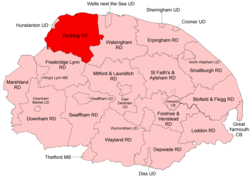
Boundaries in 1935
It was formed under the Local Government Act 1894 based on the Docking rural sanitary district. It covered an area south and east of Hunstanton.
The only changes to its boundaries during its 80 years of existence were caused by a series of expansions of Hunstanton Urban District (1902, 1925 & 1928).[2] In 1974, the district was abolished under the Local Government Act 1972, and became part of the West Norfolk district.
Parishes
| Parish | From | To | Notes |
|---|---|---|---|
| Anmer | |||
| Bagthorpe | 1935 | Component of Bagthorpe with Barmer | |
| Bagthorpe with Barmer | 1935 | Merger | |
| Barmer | 1935 | Component of Bagthorpe with Barmer | |
| Barwick | |||
| Bircham | 1935 | Merger of Bircham Newton, Bircham Toft & Great Bircham | |
| Bircham Newton | 1935 | Component of Bircham | |
| Bircham Tofts | 1935 | Component of Bircham | |
| Brancaster | |||
| Burnham Deepdale | 1935 | Added to Brancaster | |
| Burnham Market | 1929 | Burnham Westgate + Burnham Sutton… | |
| Burnham Norton | |||
| Burnham Overy | |||
| Burnham Sutton com Burnham Ulph | 1929 | Component of Burnham Market | |
| Burnham Thorpe | |||
| Burnham Westgate | 1929 | Component of Burnham Market | |
| Choseley | |||
| Dersingham | |||
| Docking | |||
| East Rudham | |||
| Fring | |||
| Great Bircham | 1935 | Component of Bircham | |
| Heacham | |||
| Heywood | |||
| Holme next the Sea | |||
| Houghton | |||
| Ingoldisthorpe | |||
| North Creake | |||
| Old Hunstanton | Known as Hunstanton before 1953 | ||
| Ringstead | |||
| Sedgeford | |||
| Shernborne | |||
| Snettisham | |||
| South Creake | |||
| Stanhoe | |||
| Syderstone | |||
| Thornham | |||
| Titchwell | |||
| Waterden | 1953 | Added to South Creake | |
| West Rudham |
References
- "Docking RD through time: Census tables with data for the Local Government District". A Vision of Britain through Time. GB Historical GIS / University of Portsmouth. Retrieved 24 June 2017.
- "New Hunstanton CP through time: Census tables with data for the Parish-level Unit". A Vision of Britain through Time. GB Historical GIS / University of Portsmouth. Retrieved 24 June 2017.
This article is issued from Wikipedia. The text is licensed under Creative Commons - Attribution - Sharealike. Additional terms may apply for the media files.