Djúpivogur
Djúpivogur is a small town and municipality (Djúpavogshreppur) located on a peninsula in the Austurland in eastern Iceland, near the island of Papey and on the fjord Berufjörður. The municipality was formed by the merger of rural communities Berunes, Buland, and Geithellur on October 1, 1992. The coastline consists of three fjords Berufjörður, Hamarsfjörður, and Álftafjörður. The town of Djúpivogur is located on a peninsula between Berufjörður and Hamarsfjörður.
| Djúpavogshreppur | |
|---|---|
 Aerial panorama of Djúpivogur | |
| Region | Eastern Region |
| Constituency | Northeast Constituency |
| Manager | Gauti Jóhannesson |
| Area | 1,133 km2 (437 sq mi) |
| Population | 456 |
| Density | 0.41/km2 (1.1/sq mi) |
| Municipal number | 7617 |
| Postal code(s) | 765 |
| Website | djupivogur |
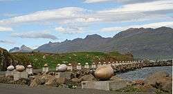
Approximately 900 m west of the town is a work of art named "Eggin í Gleðivík" (The Eggs of Merry Bay) by Sigurður Guðmundsson. The work is a replica of the eggs of 34 nesting birds in the area, and was installed in the summer of 2009.[1]
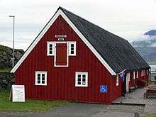
Djúpivogur is home to Langabúð, one of Iceland's oldest commercial buildings. The south end dates back to 1790, but the building only took on its present appearance when the northern part was constructed in 1850. Langabúð served many purposes, being a warehouse and slaughterhouse. Today, it is home to a café, the heritage museum and an exhibition on the Icelandic sculptor Ríkarður Jónsson, who was native to the village.[2]
Climate
Djúpivogur features a cold tundra climate (Köppen: ET). Approximately 5 kilometres west of Djúpivogur lies Teigarhorn,[3] a farm on the shores of Berufjörður, where weather observations has been commenced since 1874.[4] It is one of the oldest weather stations in the country and holds the record for the highest temperature ever recorded in Iceland, 30.5 °C (87 °F) recorded on June 22, 1939. It is also claimed that Teigarhorn reached 36.0 °C (97 °F) in September 1940, but that is not recognized by the Icelandic Meteorological Office. Temperatures above 30 °C (86 °F) are very rare in Iceland, it has occurred only 5 times since weather observations were first commenced in Iceland in the 19th century.[5] Teigarhorn features a cold tundra climate (Köppen: ET) because it doesn't have any month that has a mean temperature above 10 °C (50 °F), but the winter temperatures are mild for a cold tundra climate, and thus closely resembles a mild tundra climate or a subpolar oceanic climate (Cfc), the climate generally seen in coastal Iceland.
| Climate data for Teigarhorn (20 m),[6] 5 km (3.1 mi) from Djúpivogur (1961–1990) | |||||||||||||
|---|---|---|---|---|---|---|---|---|---|---|---|---|---|
| Month | Jan | Feb | Mar | Apr | May | Jun | Jul | Aug | Sep | Oct | Nov | Dec | Year |
| Record high °C (°F) | 16.6 (61.9) |
14.1 (57.4) |
16.0 (60.8) |
18.2 (64.8) |
24.1 (75.4) |
30.5 (86.9) |
26.7 (80.1) |
23.6 (74.5) |
23.1 (73.6) |
19.3 (66.7) |
17.8 (64.0) |
15.0 (59.0) |
30.5 (86.9) |
| Average high °C (°F) | 2.3 (36.1) |
2.6 (36.7) |
2.9 (37.2) |
5.0 (41.0) |
7.4 (45.3) |
10.3 (50.5) |
11.9 (53.4) |
11.6 (52.9) |
9.4 (48.9) |
6.7 (44.1) |
3.8 (38.8) |
2.7 (36.9) |
6.4 (43.5) |
| Daily mean °C (°F) | −0.3 (31.5) |
0.2 (32.4) |
0.4 (32.7) |
2.2 (36.0) |
4.5 (40.1) |
7.3 (45.1) |
8.8 (47.8) |
8.8 (47.8) |
6.9 (44.4) |
4.4 (39.9) |
1.3 (34.3) |
−0.1 (31.8) |
3.7 (38.7) |
| Average low °C (°F) | −2.9 (26.8) |
−2.5 (27.5) |
−2.5 (27.5) |
−0.7 (30.7) |
1.9 (35.4) |
4.7 (40.5) |
6.3 (43.3) |
6.5 (43.7) |
4.4 (39.9) |
2.0 (35.6) |
−1.4 (29.5) |
−2.9 (26.8) |
1.1 (34.0) |
| Record low °C (°F) | −17.1 (1.2) |
−18.8 (−1.8) |
−19.3 (−2.7) |
−22.9 (−9.2) |
−8.7 (16.3) |
−2.2 (28.0) |
0.0 (32.0) |
0.4 (32.7) |
−3.2 (26.2) |
−9.5 (14.9) |
−11.5 (11.3) |
−17.5 (0.5) |
−22.9 (−9.2) |
| Average precipitation mm (inches) | 129.0 (5.08) |
109.2 (4.30) |
106.8 (4.20) |
70.4 (2.77) |
76.8 (3.02) |
71.9 (2.83) |
83.8 (3.30) |
109.8 (4.32) |
110.1 (4.33) |
151.5 (5.96) |
97.8 (3.85) |
111.0 (4.37) |
1,228.5 (48.37) |
| Average precipitation days (≥ 0.1 mm) | 15.5 | 13.6 | 14.6 | 11.6 | 11.6 | 11.5 | 13.1 | 14.7 | 14.2 | 16.6 | 13.5 | 14.0 | 164.9 |
| Source: Icelandic Met Office[7][8] | |||||||||||||
History
By the early nineteenth century, Djúpivogur was 'a tiny port with a Danish colonial trading base'. Hans Jonatan, who had been a slave in Copenhagen, escaped there and became one of Iceland's first people of colour.[9]
Culture
Djúpivogur is the first and only Cittaslow town in Iceland. Cittaslow's goals include improving the quality of life in towns by slowing down its overall pace, especially in a city's use of spaces and the flow of life and traffic through them. Cittaslow is part of a cultural trend known as the slow movement.
See also
References
- "The Eggs of Merry Bay". Retrieved 25 Nov 2016.
- "Langabúð". sagatrail.is. Retrieved 2019-12-24.
- "Google Maps". Retrieved 28 July 2016.
- "TEIGARHORN BERUFJORDUR EAST ICELAND – Iceland travel". Retrieved 28 July 2016.
- "Hæsti hiti á Íslandi – Teigarhorn 22. júní 1939". Retrieved 28 July 2016.
- "Information about Teigarhorn Weather Station". Icelandic Met Office. Retrieved 27 August 2016.
- "Teigarhorn 1961–1990 Averages". Icelandic Met Office. Retrieved 28 July 2016.
- "Climatological Data for Teigarhorn". Icelandic Met Office. Retrieved 28 July 2016.
- Kristín Loftsdóttir and Gísli Pálsson, 'Black on White: Danish Colonialism, Iceland and the Caribbean', in Scandinavian Colonialism and the Rise of Modernity: Small Time Agents in a Global Arena, ed. by Magdalena Naum and Jonas M. Nordin, Contributions To Global Historical Archaeology Volume, 37 (New York: Springer, 2013), pp. 37--52 (quoting p. 47). doi:10.1007/978-1-4614-6202-6_3
External links
| Wikimedia Commons has media related to Djúpivogur. |