Diego Ramírez Islands
The Diego Ramírez Islands (Spanish: Islas Diego Ramírez) are a small group of islands located in the southernmost extreme of Chile.
 Map of Diego Ramirez Islands | |
 Diego Ramírez Islands Islas Diego Ramírez Location south of the South American Mainland | |
| Geography | |
|---|---|
| Coordinates | 56°29′S 68°44′W |
| Area | 1 km2 (0.39 sq mi) |
| Highest point | 179 m (587 ft)[1] |
| Administration | |
| Region | |
| Province | Antártica Chilena |
| Commune | Cabo de Hornos |
| Demographics | |
| Population | Chilean Navy station |
| Additional information | |
| NGA UFI=-879674 | |
Geography
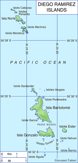
The islands lie about 105 km (65 mi) west-southwest of Cape Horn and 93 km (58 mi) south-southeast of Ildefonso Islands, stretching 8 km (5 mi) north-south. They are divided into a smaller northern group with six islets, and a larger southern group, separated by a passage 3 km (1.9 mi) wide. The two largest islands, Isla Bartolomé and Isla Gonzalo, both lie in the southern group. Águila Islet (Islote Águila), the southernmost land of the group, is at 56°32'9"S.
Diego Ramírez Islands lies about 350 km north of Sars Bank, a seamount that may have been once an island.[2]
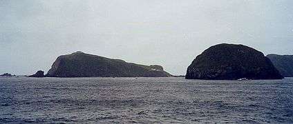 View of the Diego Ramirez Islands
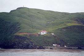 The Chilean station on Isla Gonzalo, with the beacon visible at highest point of the island
History
They were first sighted on 12 February 1619 by the Spanish Garcia de Nodal expedition, and named after the cosmographer of the expedition, Diego Ramírez de Arellano.[3] They were cited as the southernmost land mass plotted as of that time, and retained the distinction for 156 years, until the discovery of the South Sandwich Islands in 1775.
In 1892 the Chilean government rented the islands to Pedro Pablo Benavides for fishing and on condition that a lighthouse, a port and a school were built.[4] Later the rent was transferred to Koenigswerther and Pasinowich.
The Chilean Navy established a meteorological station above Caleta Condell, a small cove on the northeast side of Isla Gonzalo (Gonzalo Island), in 1957, and resupply it several times each year.[5] This is the southernmost inhabited outpost outside Antarctica, even if the South Sandwich Islands are regarded as part of South America, since the Argentinian station on Thule Island was dismantled in June 1982 (in the aftermath of the Falklands War). The next southerly inhabited outpost of South America is the lighthouse of Cape Horn. Cruise ships occasionally pass by on their way to and from Antarctica.
The islands are an important nesting site for a number of southern seabirds, including the black-browed albatross, shy albatross, grey-headed albatross, rockhopper penguin and southern giant-petrel.
Climate
The islands have a tundra climate (ET), with abundant precipitation.
| Climate data for Diego Ramírez Islands (Isla Gonzalo) 42 m asl (1981–2010 normals) | |||||||||||||
|---|---|---|---|---|---|---|---|---|---|---|---|---|---|
| Month | Jan | Feb | Mar | Apr | May | Jun | Jul | Aug | Sep | Oct | Nov | Dec | Year |
| Record high °C (°F) | 20.0 (68.0) |
19.4 (66.9) |
21.3 (70.3) |
19.3 (66.7) |
13.0 (55.4) |
15.5 (59.9) |
14.0 (57.2) |
13.0 (55.4) |
14.0 (57.2) |
14.0 (57.2) |
16.0 (60.8) |
19.6 (67.3) |
21.3 (70.3) |
| Average high °C (°F) | 9.5 (49.1) |
9.8 (49.6) |
9.2 (48.6) |
8.0 (46.4) |
6.6 (43.9) |
5.5 (41.9) |
5.3 (41.5) |
5.4 (41.7) |
6.1 (43.0) |
6.7 (44.1) |
7.6 (45.7) |
8.7 (47.7) |
7.4 (45.3) |
| Daily mean °C (°F) | 7.6 (45.7) |
7.9 (46.2) |
7.2 (45.0) |
6.1 (43.0) |
4.8 (40.6) |
3.7 (38.7) |
3.5 (38.3) |
3.5 (38.3) |
4.1 (39.4) |
4.8 (40.6) |
5.7 (42.3) |
6.7 (44.1) |
5.5 (41.9) |
| Average low °C (°F) | 5.6 (42.1) |
5.9 (42.6) |
5.1 (41.2) |
4.2 (39.6) |
2.9 (37.2) |
1.9 (35.4) |
1.6 (34.9) |
1.5 (34.7) |
2.1 (35.8) |
2.9 (37.2) |
3.6 (38.5) |
4.7 (40.5) |
3.5 (38.3) |
| Record low °C (°F) | −3.0 (26.6) |
−2.0 (28.4) |
−3.0 (26.6) |
−4.2 (24.4) |
−5.0 (23.0) |
−8.0 (17.6) |
−7.0 (19.4) |
−9.0 (15.8) |
−6.8 (19.8) |
−4.0 (24.8) |
−3.4 (25.9) |
−3.8 (25.2) |
−9.0 (15.8) |
| Average precipitation mm (inches) | 136.8 (5.39) |
96.4 (3.80) |
111.0 (4.37) |
122.9 (4.84) |
114.1 (4.49) |
90.6 (3.57) |
89.4 (3.52) |
93.6 (3.69) |
76.6 (3.02) |
114.2 (4.50) |
114.5 (4.51) |
102.0 (4.02) |
1,262.1 (49.72) |
| Average precipitation days | 21.30 | 17.68 | 18.92 | 17.50 | 16.29 | 15.71 | 17.41 | 17.96 | 15.76 | 19.01 | 20.41 | 18.84 | 216.79 |
| Source 1: Météo climat stats[6] | |||||||||||||
| Source 2: Météo Climat [7] | |||||||||||||
See also
References
- United States Hydrographic Office, South America Pilot (1916), page 256
- Martinic B., Mateo (2019). "Entre el mito y la realidad. La situación de la misteriosa Isla Elizabeth de Francis Drake" [Between myth and reality. The situation of the mysterious Elizabeth Island of Francis Drake]. Magallania (in Spanish). 47 (1). doi:10.4067/S0718-22442019000100005. Retrieved December 21, 2019.
- Dingwall, P.R., ed. (1995). Progress in Conservation of the Subantarctic Islands, p. 107. The World Conservation Union. ISBN 2-8317-0257-7.
- Octavio Errázuriz Guilisasti and Germán Carrasco Domínguez, Historia de las Relaciones Exteriores de Chile, Arbritaje británico de 1899-1903, Editorial Andrés Bello, 1968, Santiago de Chile, page 93
- Dingwall (1995), p. 109.
- "Moyennes 1981-2010 Chili" (in French). Retrieved 11 November 2019.
- "Météo Climat stats for Iles Diego Ramirez". Météo Climat. Retrieved 11 November 2019.