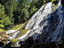
Diamond Creek Falls
Diamond Creek Falls is a waterfall formed along Gibson Canyon on the north end of Willamette National Forest, east side of the city of Oakridge in Lane County, Oregon.[1] Access to Diamond Creek Falls is located along Oregon Route 58 through trail paths that lead down to the stream and the base of the waterfall.
| Diamond Creek Falls | |
|---|---|
 | |
| Location | Willamette National Forest |
| Coordinates | 43.60722°N 122.14333°W |
| Type | Veiling Horsetail |
| Elevation | 4,195 ft (1,279 m) |
| Total height | 120 ft (37 m) |
Trail
From the parking lot and to the left of the interpretive kiosk is the beginning of the 3.4-mile (5 km) loop hike upstream of the waterfall on the Salt Creek Falls and Diamond Creek Falls trails.[2] The Salt Creek Falls trail starts with a paved walkway along Salt Creek that leads to a picnic area. Past the picnic area is a bridge over Salt Creek that leads to a faint pathway where the trail divides. Following the right side at the junction leads to about 0.2 miles (0 km) of a quick climb that ends in a wide view of the surrounding canyon. Past this viewpoint, the Diamond Creek Falls Trail continues for about 1.1 miles (2 km) past Too Much Bear Lake and ends in a junction that leads to the waterfall, which has access to its base over basalt steps, fissures and boulders.[3]
See also
References
- "Diamond Creek Falls - Lane County, Oregon". Northwest Waterfall Survey. Retrieved 10 June 2017.
- Grubbs, Bruce (1999). Hiking Oregon's Central Cascades. Globe Pequot Press. p. 167. ISBN 1560448733.
- "Diamond Creek Falls Trail #3598". U.S. Forest Service. Retrieved September 11, 2015.