Desaguadero River
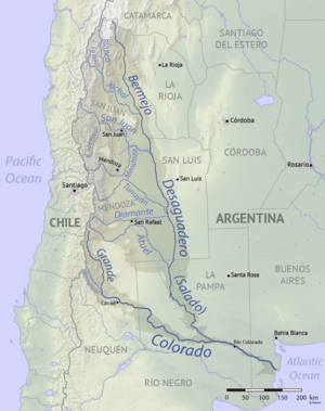
The Desaguadero River (Spanish: Río Desaguadero, Spanish pronunciation: [ˈri.o ðesaɣwaˈðeɾo]) is a river in Argentina. Originating near the Tipas volcano in La Rioja at about 5,500 m (18,000 ft) elevation, the river is known in its upper reaches as the Bermejo or Vinchina. In its lower reaches it is also known as the Salado. It joins the Colorado River in La Pampa Province near Pichi Mahuida. The Desaguadero River has a total length of 1,498 km (931 mi) and its drainage basin is about 260,000 km2 (100,000 sq mi).
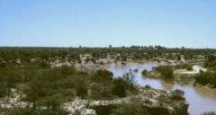
It is one of the major rivers that supplies the irrigated areas of Cuyo, and it flows in the eastern border of that region.[1] Due to use of its waters for irrigation, the river is a small, shallow stream for most of the year despite its great length, and only occasionally does surface flow reach the Colorado.
Tributaries include the Jachál, San Juan, Tunuyán, Diamante and Atuel Rivers.
History
The river marked the traditional boundary between the vice-royalties of Buenos Aires and Peru.[2]
References
- Kenneth D. Frederick (1975). "Historical Growth". Water Management and Agricultural Development: A Case Study of the Cuyo region of Argentina (2011 ed.). Johns Hopkins University Press. p. 23.
- David Marley. Wars of the Americas: A Chronology of Armed Conflict in the Western Hemisphere, 1492 to the Present. ABC Clio. p. 588.