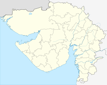
Dediapada
Dediyapada (ગુજરાતી : ડેડીયાપાડા) is a Tehsil and town in Narmada District with a sizable population of Adivasi communities in which Vasava and Tadvi form the majority. This taluka is bounded by Zaghadia taluka (Bharuch), Sagbara taluka, Nandod taluka (Separated by Narmada river), Maharashtra state and Mandavi taluka (Surat district). Dediyapada is well connected with Bharuch, Ankleshwar, Rajpipla, Netrang, Sagbara, Akkalkuva and Shahada by National Highway & State Highway. Despite being remote in location, it is well connected by Gujarat and Maharashtra ST Buses.
Dediyapada Dediyapada | |
|---|---|
 Dediyapada  Dediyapada | |
| Coordinates: 21.62315°N 73.5830353°E | |
| Country | |
| State | Gujarat |
| District | Narmada |
| Time zone | UTC+5:30 (IST) |
| Pincode | 393 040 |
| Area code(s) | 02649 |
| Vehicle registration | GJ-22 |
Located in the divine forest range of Shoolpaneshwar Wildlife Sanctuary, it is a Tehsil place and second big town of Narmada District.
History
Geography
It is well covered by the forest of Shoolpaneshwar WLS. Varied terrain makes it a good place. This district has variety of flora and fauna.
Tourist Places
Shoolpaneshwar Wildlife Sanctuary
Ninai Waterfall
Sagai Eco Camp Site
Mal-Samot
Civic Administration
It is administered by local government body called Municipality consisting of elected members from the area.
Culture
Dediyapada is a confluence of cultures from Gujarat and Maharashtra. Population mainly consists of tribes.
Economy
Here the economy mainly runs on agriculture, herbs and wood industries.
Sports