Dalton, Richmondshire
Dalton is a village and civil parish in North Yorkshire in England.[2][3] Dalton is situated about six miles north-west of Richmond and about five miles south-east of Barnard Castle within the council district of Richmondshire and close to the A66 transpennine trunk road. It was listed in the Domesday book. The Dalton parish boundary includes the village itself as well the houses at Dalton Heights (off the road to Newsham) plus numerous surrounding farms. The population of the parish was 147 according to the 2001 census,[4] increasing to 181 at the 2011 Census.[1]

| Dalton | |
|---|---|
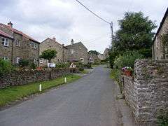 Looking through Dalton | |
 Dalton Location within North Yorkshire | |
| Population | 181 (2011 census)[1] |
| OS grid reference | NZ114084 |
| District | |
| Shire county | |
| Region | |
| Country | England |
| Sovereign state | United Kingdom |
| Post town | RICHMOND |
| Postcode district | DL11 |
| Dialling code | 01833 |
| Police | North Yorkshire |
| Fire | North Yorkshire |
| Ambulance | Yorkshire |
| UK Parliament |
|
Dalton is founded on a farming community, both arable and stock, and nestles on a stream or beck which is a tributary of the River Swale. The Dalton & Gayles Village Hall, which is shared with the neighbouring village of Gayles, is located in Dalton; there is also a Church of England church, St James's, built in 1897.
The name Dalton comes from Old English and means farmstead or village in a valley.[5]
To the South of Dalton there are the remains of a camp called ‘Castle Steads’, if you continue further South there is a block of stone called ‘Stone Man’ which used to be a large landmark. However, these stones were taken away to make fences. A mile South-east of the Stone Man a stone chest was found which had a ‘kale pot’ which is said to have contained money.[6]
In 1835 an allowance of £40 was given to the schoolmaster by the Kirby-Ravensworth hospital for the education of the poor children.[7] By 1890 there was a mixed school attended by 50 students.[8]
References
- UK Census (2011). "Local Area Report – Dalton Parish (E04007472)". Nomis. Office for National Statistics. Retrieved 16 August 2019.
- Ordnance Survey: Landranger map sheet 92 Barnard Castle & Richmond (Teesdale) (Map). Ordnance Survey. 2011. ISBN 9780319228982.
- "Ordnance Survey: 1:50,000 Scale Gazetteer" (csv (download)). www.ordnancesurvey.co.uk. Ordnance Survey. 1 January 2016. Retrieved 18 February 2016.
- UK Census (2001). "Local Area Report – Dalton Parish (36UE031)". Nomis. Office for National Statistics. Retrieved 16 August 2019.
- Mills, A.D. (2011) [first published 1991]. A Dictionary of British Place Names (First edition revised 2011 ed.). Oxford: Oxford University Press. p. 146. ISBN 9780199609086.
- Hinson, Colin. "Kirkby Ravensworth: Geographical and Historical information from the year 1890". Bulmer's History and Directory of North Yorkshire (1890). Retrieved 26 April 2013.
- Hinson, Colin. "Kirkby Ravensworth". Lewis's Topographical Dictionary of England 1835. Retrieved 26 April 2013.
- Hinson, Colin. "Kirkby Ravensworth: Geographical and Historical information from the year 1890". Bulmer's History. Retrieved 26 April 2013.
External links

- Dalton in the Domesday Book