Daehanjiji
Daehanjiji (Korean: 대한지지; Hanja: 大韓地誌) is a Korean geography book about the Great Korean Empire, written by Hyeun Chae (Korean: 현채; Hanja: 玄采) and published by Gwangmun-sa (Korean: 광문사; Hanja: 廣文社), Seoul. Hyeun Chae wrote Daehanjiji, a two-volume set of Korean elementary school geography books, in 1899 translating and compiling Japanese and Korean sources. The titles, authors, and chronologies of source material for the compilation are not always stated, yet Gomatsu Susumu(小松運)'s Chōsenhachidō-shi(朝鮮八道誌; Joseon Paldo-ji, 1887)[1] and Matsumoto Nikichi(Kendo)(松本仁吉; a.k.a. 謙堂)'s Chōsenchishi Yoryaku (朝鮮地誌要略; Joseon Jiji Yoryak, 1894)[2] and their styles are suspected as primary sources and models of emulation. The author states in the postface that he employed several Japanese geographies on Korea, and that he supplemented these with the historical sections from Shinjeung Dongguk Yeojiseungram.[3] Daehanjiji was published in 1899 and reprinted in 1901. It gave a summary description of late 19th century Korean geography with greater emphasis on physical geography. The written language conformed to the then innovative Gukhanmun Honyongche, one combining han'geul and hanja, and was popular for the relative ease of deciphering. As the first western style geography textbook published in late Joseon dynasty, it contributed to the Gaehwa movement, the opening up to enlightenment for the Korean masses and raising awareness and unity as a nation by inviting commoners to learn everything they could about the Korean Empire and its landscape, namely the Korean Peninsula at late 19th century. It was foreworded by Lee Gyu-hwan (Korean: 이규환; Hanja: 李圭桓), Director of Editorial Office, Ministry of Education. Daehanjiji was employed in the school system, but was banned, confiscated, and burned by Protectorate General by Notice No. 72 of Nov. 19, 1910.[4]
.jpg)
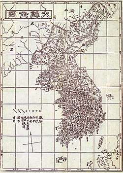
One of many geographies published in Gojong's reign
Daehanjiji was the last of the three geographical works of the latter 1900s; the provincial gazetteers that were written from 1871 onward, Joseon Jiji (朝鮮地誌; 1895, 1 vol.), and Dahanjiji itself. Its reprinting in 1901 was followed by other geographical works by authors who were inspired by its novelty, yet who were disappointed for its brevity and obvious omissions. Thus were published Daehan Shinjiji (大韓新地志, Jang Jiyeon, 1907), Chodeung Dahanjiji (初等大韓地誌, An Jonghwa, 1907), and again Chodeung Dahanjiji (初等大韓地誌 An Jonghwa, Ryun Yeon, 1908), which described Usan Island as lying to the Southeast of Ulleung Island. As for institutional innovations in the local administrations since the Seven Year War of 1593 down to 1904, the 1908 Jeungbo Munheon Bigo, The Expanded Encyclopedia of the Eastern Nation, succinctly noted the redevelopment of Ulleung Island of 1883, its promotion to Uldo County of 1900, and the incorporation of Usan Island under Uldo County jurisdiction.
Daehan Jiji Controversy: Japanese MOFA's 1952 memo., "Were Koreans aware of claimed sovereignty over Dokdo in 1899?"
Daehanjiji describes the domain of the Great Korean Empire as stretching from 33°15′N to 42°25′N and from 124°30′E to 130°35′E, which would exclude the Liancourt Rocks (located at 37°14′30″N 131°52′0″E), ownership of which is claimed by both Korea and Japan.[5][6][7]
The said four corners of the Korean Peninsula given in the overview, first chapter of Daehanjiji, are as follows, yet it is not clear which locations the figures might represent, obscuring further analysis that might offer a solution either way.
- Southern limit: 33°15′N
- Northern limit: 42°25′N
- Western limit: 124°30′E
- Eastern limit: 130°35′E
Identifying the actual placenames of Korea lying behind the abstract figures I
Although Daehanjiji garnered praise as a pioneering western-style textbook in late Joseon dynasty, it was criticized for its overt dependence on Japanese geographies. It had borrowed heavily from the Japanese sources in its overview, format, and content material, and its longitude-latitude co-ordinates were literally translated from the Japanese books rather than taking Korean measurements conducted by the Korean government.[8] The so-called four limits of the Korean peninsula, including the eastern limit ~~ that has drawn heavy criticism, have been identified in such prior Japanese geographies as follows.[9]
Identifying the actual four corners of Korea lying behind the abstract figures II
Fortunately, an identical set of longitude-latitude four-corner limits has been identified in the 1907 geography by Tokunaga Isamijo's (德永勲美) Kankoku Shoran (韓國總覽; 한국총람)[16] where the real geographical locations are given beside the abstract so-called four corners figures.[17]
- Southern limit: 33°15′N at Moseul-po, Jeju Island
- Northern limit: 42°25′N at Nokdun-do(鹿屯島)
- Western limit: 124°30′E at Soyuhyen-gak(小乳縣角), or Jangsan-goc(長山串), Hwanghae Province
- Eastern limit: 130°35′E at Duman River(豆滿江) estuary, N. Hamgyeng Province
In light of these actual locations, the question raised by the Japanese MOFA becomes more understandable in concrete geographical terms. To reiterate JMOFA's challenge, the fact that Daehanjiji lists these four corner limits to describe Korea indicates Koreans did not regard Dokdo-Takeshima (Liancourt Rocks) as Korean territory. In refutation, it has been noted the fact that Ulleung Island around that time, with a longitude measurement of 130°57′E according to the Japanese Navy[18] and 130°58′E according to the British Navy,[19] also lies outside the so-called four corners but has always been considered Korean territory indicates the so-called four-corner limits should not be taken literally, as they might have meant something quite different in the minds of those who first coined them.[20] In addition, it has further been brought to attention that the following locations also lie outside the so-called four-corner coordinates yet they are sovereign territories at least since Gojong's reign.[21]
From 1883 Kan’ei Suiroshi to 1907 Kankoku Shoran: Korean territories outside the four coordinates
- Korean territories beyond the southern limit : Gapado at 33°09′34″N,[22] Marado at 33°06′40″N[23]
- Korean territories beyond the northern limit : Pungseori (Hamgyeongbukdo Onseonggun Pungseori Yuweonjin) at 43°00'36″N
- Korean territories beyond the western limit : Bidanseom (Pyeonganbukdo Shindo-gun Bidan-seom Rodongja-gu) at 124°10'47″E
- Korean territories beyond the eastern limit : Raseonteukgeup-shi Seonbong-gun Wuam-ri at 130°41'32″E; Ulleung Island (Takeshima(竹島) in Edo Japanese), 130°54'E; Gwaneumdo (Seommok, G'aksaeseom), 130°55'E; Jukdo(竹島; Daes'seom), 130°56'E; Dokdo(于山島; 芋山島; 石島; 獨島; Dokseom; Dolseom; Matsushima (松島) in Edo Japanese),[24] 131°52'E
The current limits of modern Korea, South and North combined
- 한국 최남단: 북위 33°06'37 ROK Jeju Teukbyeol Jachi-do Seogwipo-shi Daejeong-eup Mara-do
- 한국 최북단: 북위 43°00'36 DPRK Hamgyeongbukdo Onseong-gun Pungseo-ri
- 한국 최서단: 동경 124°10'47 DPRK Pyeong'anbukdo Shindo-gun Bidan-seom Rodongja-gu
- 한국 최동단: 동경 131°52'10.38 ROK Gyeongsangbukdo Ulleung-gun Ulleung-eup Dokdo-ri
References
- 朝鮮八道誌 小松運 http://db.mkstudy.com/mksdb/e/korean-geography/book/9836/
- (新編) 朝鮮地誌要略. 松本仁吉(松本謙堂) 1894. http://db.mkstudy.com/mksdb/e/korean-geography/book/9892/
- Gwangmu 3, Dec. 25, Postface: 大韓地誌跋 余所編地誌 本 諸日人所記, 叅 諸輿地勝覽旁 及部府掌 故而其所敍述 略倣, 古山水記, 簡嚴之意少而悠揚之詞多蓋變體也. 舍正體而爲變體 者奈何 余以爲今便 小學童子課習地誌, 而其文簡湥(淚의 오자?)一如禹貢水經之 爲則其不便有四, 難讀一也, 難記一也, 難欽動一也, 難開發一也, 以此四 難望其成功不亦迂乎! 故余之爲此也. 要使難易適得相半難不至太蕀 而不至太俚渙然冰釋怡然理順俱其名勝. 敍述本出於日人一時遊歷 之際其於山脈水脈或不能無失之病 而顧以敎課事急不能磨歲月 博考腒此 其所愧也. 世之君子其或蹋而輯之匡余過誤而歸于至當則 斯厚幸云 光武三年十二月二十五日 白堂 玄采跋
- 조선총독부관보제69호고시제72호(官報:1910년 11월 19일), http://pds11.egloos.com/pds/200812/27/11/b0016211_495594980fcd7.jpg
- Korea's MOFA(外交部)(1977), 「Japanese Memo. 2」(1954. 2. 10), 『Dokdo Documents 1(獨島關係資料集1)-Memoranda(往復外交文書)(1952~1976) -』, p. 57
- Shimojo Masao (下條正男)(1998. 8), 「Dokdo Issues」, 『Han'guk Nondan(韓國論壇)』 pp. 108, 132~152; (2007. 9), 「Behold, ye historical revisionists of Japanese territory 「Takeshima」(日本の領土「竹島」の歷史を改竄せし者たちよ)」, 『Shokun!(諸君!)』, Bungeishunjū-sha(文藝春秋社); "Takeshima(KoreanㆍDokdo), whose is it, Korean or Japanese"(2004, Bungeishunjū-sha, p. 115)
- Muzuma Masanori(水間政憲, 2012) "1899 Korean textbook proving ‘No Dokdo within Korea’ found" (「1899年発行の韓国の教科書に『竹島は韓国領でない』証拠発見」Japanese news article) http://www.news-postseven.com/archives/20121015_149188.html
- 윤소영(2013). 근대 일본 관찬 사찬 지리서에 나타난 독도 인식. 한국독립운동사연구소 월례발표회 292. p. 19
- Hosaka Yuji
- 환영수로지(寰瀛水路誌; 海軍水路部 嘉納謙作; Kanō Kensaku, Japanese Navy's Hydrographic Office, 1883), http://mblogthumb2.phinf.naver.net/20140421_157/kskimpak_1398081500975MX4UE_JPEG/%C8%AF%BF%B5%BC%F6%B7%CE%C1%F6.jpg?type=w2
- 환영수로지(寰瀛水路誌; Kan’ei Suiroshi, 海軍水路部 嘉納謙作; Kanō Kensaku, Japanese Navy's Hydrographic Office, 1886), http://dl.ndl.go.jp/info:ndljp/pid/1084068/17
- 조선팔도지(朝鮮八道誌; Chōsenhachidō-shi, 小松運; Gomatsu Susumu, 1887), http://dl.ndl.go.jp/info:ndljp/pid/766919/10
- 신찬조선국지도(新撰朝鮮国地図; Shinsen Chōsenkoku Chizu, 林正; Hayashi Tadashi, 1894.7) http://dl.ndl.go.jp/info:ndljp/pid/767582/7
- 신찬조선지리지(新撰朝鮮地理誌; Shinsen Chōsen Chiri-shi, 大田才次郎; Ota Saijiro, 1894), http://www.tanaka-kunitaka.net/takeshima/chosenchirishi-1894/08.jpg Archived 2016-09-15 at the Wayback Machine
- 조선수로지(朝鮮水路誌; Chōsen Suiroshi, 海軍水路寮; Japanese Navy's Hydrographic Office, 1894.11) http://www.geocities.jp/tanaka_kunitaka/takeshima/hydrograph1894/1894-3s.jpg
- 1907 韓國總覽① 德永勳美 http://db.mkstudy.com/mksdb/e/korean-geography/book/9881/
- The so-called four corners of Korea given by Kankoku Shoran(韓國總覽) are given in the bibliographical introduction to Očerk Korei (한국개관해제), Kim Yeongsu, in 『한국개관(Очерк Кореи)』Part I., Н.В. Kyuner(Кюнер Н.В.). The Russian Oriental Institute., 1912. tr. Kim, Jongheon, Northeast History Foundation, 2012. pp. 24-25
- "鬱陵島(一名松島); 該島は我隠岐を距る北西四分の三、西約一百四十里、朝鮮江原道海岸を距る約八十里、洋中に孤立し全島嵯峨たる円錐形の丘陵集合して、樹木之を蔽う。而して其中心北緯三十七度二十二分、東経一百三十度五十七分、露測に據る。" 水路雑誌第41号(1883)
- Matu-sima at Peak at 37°30'00N 130°58'00E by Ward 1859, China Sea Directory Vol. IV, Hydrographic Office, Admiralty, Great Britain. 1873. p. 367
- Hosaka Yuji. p. 117
- Gapado and Marado are listed in Sinjeung Dongguk Yeoji Seungram meaning they were recognized as Korean territories at least since the 15th century, and provincial gazetteers and geographies record they have been developed and inhabited in Gojong's reign years.
- 김태호(2002). 가파도 해안의 지형경관. "최북단은 상동 해안으로 33°10′16″N이며, 최남단은 자장코지 해안으로 33°09′34″N 이다. 최동단은 볼락코지 해안으로 126°16′52″E이며, 최서단은 큰악근녀 해안으로 126°15′56″E이다."
- 김주한 et al.(2003) GIS 객체 위치표시 방안(국가영역식별자 : National Area IDentifier)에 관한 연구. A Study of Indicating GIS Object with NAID. 2003년도 대한토목학회 정기 학술대회, 2003.10, 4387-4390.
- a.k.a. Burunsemi, Deokseom; Shin Gyeongjun of the 1700s states that this island is called Matsushima by the Japanese.