Cuncunani
Cuncunani (possibly from Aymara kunkuna a plant (Distichia muscoides),[2] -ni a suffix to indicate ownership, "the one with kunkuna") is a mountain in the Vilcanota mountain range in the Andes of Peru, about 5,400 metres (17,717 ft) high. It is situated in the Puno Region, Carabaya Province, Corani District. Cuncunani lies in the east of the large glaciated area of Quelccaya (Quechua for "snow plain") and southeast of Cunorana.[1]
| Cuncunani | |
|---|---|
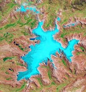 The glaciated area of Quelccaya with Cuncunani on the right (NASA, 2010) | |
| Highest point | |
| Elevation | 5,400 m (17,700 ft) [1] |
| Coordinates | 13°55′32″S 70°46′47″W |
| Geography | |
 Cuncunani Peru | |
| Location | Peru, Puno Region |
| Parent range | Andes, Vilcanota |
References
- escale.minedu.gob.pe - UGEL map of the Carabaya Province (Puno Region)
- Jorge Araya-Presa, Francisco A. Squeo, Lina Barrientos, Eliana Belmonte, Manuel Mamani, Gina Arancio, Manual de Plantas y Canciones en Aymara, PROYECTO EXPLORA-CONICYT ED7/02/085: Etnobotánica y Etnomusicología Aymara: Divulgación de la sabiduría ancestral sobre plantas nativas del Altiplano de Arica, Chile, 2003
This article is issued from Wikipedia. The text is licensed under Creative Commons - Attribution - Sharealike. Additional terms may apply for the media files.