Cumberland Pass
Cumberland Pass (elevation 12,034 feet (3,668 m))[1] is a high mountain pass in the Sawatch Range of the Rocky Mountains of Colorado. It is located in Gunnison County and in the Gunnison National Forest.
| Cumberland Pass | |
|---|---|
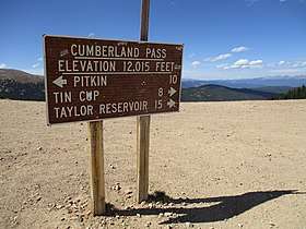 Sign marking Cumberland Pass. | |
| Elevation | 12,034 ft (3,668 m)[1] |
| Traversed by | Forest Road 765 |
| Location | Gunnison County, Colorado, U.S. |
| Range | Sawatch Range |
| Coordinates | 38.6891616°N 106.4841944°W |
| Topo map | Cumberland Pass |
The pass is traversed by Forest Road 765 and can be accessed from the towns of Tincup to the north and Pitkin to the south. The road is gravel and is closed seasonally due to heavy snowfall, typically from November until May.[2]
The Cumberland Pass road was built in 1882, connecting the mining towns of Tin Cup to the north and Pitkin to the south. The wagon road allowed ore from Tincup-area mines to be shipped to the Quartz Station of the Denver & South Park Railroad. The ore was then shipped by rail east through the Alpine Tunnel.[3]
Evidence of past and present human activities can be found at Cumberland Pass. Mining prospects and abandoned mines dot the landscape and a network of dirt roads and trails are popular with motorcycle, ATV, and four-wheel-drive vehicle users. [4][5]
References
- "Cumberland Pass". Geographic Names Information System. United States Geological Survey.
- "Roads Maintained Summer/Winter by Gunnison County Public Works Department". Gunnison County. Retrieved 13 April 2020.
- Vandenbusche, Duane (1980). The Gunnison Country. Gunnison, Colorado: B&B Printers. LCCN 80-070455.
- "Cumberland Pass". PitkinColorado.com. Archived from the original on 25 August 2017. Retrieved 13 April 2020.
- "Cumberland Pass Jeep Road". atvtrails.org. Archived from the original on 24 April 2019. Retrieved 13 April 2020.
External links
