Croxton Kerrial
Croxton Kerrial (pronounced "crow-sun kerry-ul" [ˈkroʊsən ˈkɛrɨl]) is a village and civil parish in the Melton borough of Leicestershire, England, 6.6 miles (10.6 km) south-west of Grantham, 7.9 miles (12.7 km) north-east of Melton Mowbray, and 0.5 miles (0.8 km) west of the Leicestershire boundary with Lincolnshire. The civil parish, which includes the village of Branston had a population of 530 at the 2011 census.[1][2]
| Croxton Kerrial | |
|---|---|
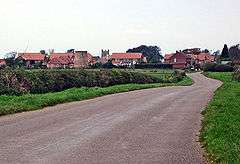 Croxton Kerrial | |
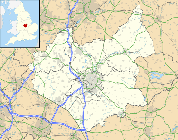 Croxton Kerrial Location within Leicestershire | |
| Population | 530 (2011 Census) |
| OS grid reference | SK835295 |
| • London | 97 miles (156 km) SSE |
| District |
|
| Shire county | |
| Region | |
| Country | England |
| Sovereign state | United Kingdom |
| Post town | GRANTHAM |
| Postcode district | NG32 |
| Dialling code | 01476 |
| Police | Leicestershire |
| Fire | Leicestershire |
| Ambulance | East Midlands |
| UK Parliament | |
History
In medieval times, Croxton Abbey, a Premonstratensian house, lay within the locality. The manor of Croxton was granted (in part-exchange for the manor of Kettleburgh, Suffolk) by King Henry III in May 1242 to Bertram de Criol or Crioill, Lord Warden of the Cinque Ports[3] (whose seat was at Ostenhanger in Stanford, Kent[4]), from whom the name "Kerrial" is derived. Nicholas de Crioll, a successor to Bertram as Warden of the Cinque Ports, married the heiress of William de Auberville the younger, whose grandfather in 1192 founded the Premonstratensian abbey of Langdon, near West Langdon, Kent as from Leiston Abbey in Suffolk, which had been founded by his father-in-law Ranulf de Glanville in 1183.[5] On 28 December 1246 the king granted a Monday weekly market to Nicholas de Crioll, and his heirs, at his manor of Croxton, and a yearly fair on the vigil, feast and morrow of St Barnabas (June 10–12).[6]
Governance
Lying across the historic county boundaries of Leicestershire and Lincolnshire from a very early time, Croxton Kerrial once formed an ancient parish within the hundred of Framland.[7]
From 1894 to 1935, Croxton Kerrial formed part of the Belvoir Rural District, when it was amalgamated into Melton and Belvoir Rural District, both of which were within the administrative county of Leicestershire.[7]
In 1974, as part of the provisions of the Local Government Act 1972, Croxton Kerrial was transferred into the newly created non-metropolitan district of Melton, while remaining within the county of Leicestershire.
Geography
Croxton Kerrial can be described as hilly, its highest point being 500 ft (152 m) above sea level.[8] Much of the land surrounding Croxton Kerrial is arable farmland.
Nearby places are Knipton and Harston (both in Belvoir parish), Belvoir Castle, Hungerton (over the border in Lincolnshire), Eaton and Sproxton. South Croxton is a separate village and civil parish in the Charnwood borough of Leicestershire, named to reflect its position south of Croxton Kerrial.
A local landmark is the Croxton Water Spout, part of an old water system sourced from a local spring, which was refurbished in 2003 as part of the Millennium celebrations.
Education and worship
Croxton Kerrial Church of England Primary School converted to academy status in 2013 under the Leicester Diocese Charitable Trust.[9] An Ofsted report in June 2015 graded the school as good. It had a roll of 73.[10]
The Anglican church, part of the Diocese of Leicester, is dedicated to both Saint Botolph and Saint John the Baptist.[11] There is a former Methodist chapel in the village.[12]
Sport
Croxton Kerrial currently has one senior football team, CK Dons, which plays in the Leicester and District Football League.
Croxton also has a Sunday cricket team, which plays in the GMCA Division 3.
South-west of the village (beyond Croxton Park) is the disused Croxton Park race course. Its last meeting was held on 2 April 1914.[13]
References
- United Kingdom Census 2001. "Croxton Kerrial CP (Parish)". neighbourhood.statistics.gov.uk. Retrieved 15 June 2007.
- Leicestershire County Council (2001). "Census 2001 Parish Profile: Croxton Kerrial" (PDF). Retrieved 15 June 2007.
- Calendar of Patent Rolls: Henry III, 1232–1247 (HMSO London 1906), p. 286.
- T. Philipott (with J. Philipott), Villare Cantianum, or, Kent Surveyed and Illustrated (Printed by William Godbid, London 1659), 'Stamford, Folkestone Hundred', p. 302. (Umich/EEBO)
- E. Foss, The Judges of England: with sketches of their lives (London, 1848), p. 185-86.
- Calendar of Charter Rolls: Henry III, 1226–1257 (HMSO 1903), p. 311.
- A Vision of Britain through Time. "A vision of Croxton Kerrial AP/CP". Retrieved 15 June 2007.
- meltononline.co.uk (2006). "Croxton Kerrial and Branston - About the Parish Council". Archived from the original on 28 September 2007. Retrieved 15 June 2007.
- School site Retrieved 4 April 2016.
- Ofsted report Retrieved 4 April 2016.
- Many details and some pictures of the church can be found here. Retrieved 17 November 2019.
- Conservation area [www.melton.gov.uk/download/downloads/id/.../croxton_kerrialpdf.pdf Retrieved 4 April 2016.]
- "Sporting Chronicle". Archived from the original on 29 December 2008. Retrieved 31 August 2009.
External links
| Wikimedia Commons has media related to Croxton Kerrial. |
- Croxton Kerrial, GENUKI article.
- Croxton Kerrial, a Leicestershirevillages.com community forum.