Crossconnell
Crossconnell is a townland in the Urris Valley, located in the North-West corner of the Inishowen Peninsula. It is located at 55° 16' 31" N, 7° 26' 35" W.
It is in the Electoral Division of Dunaff, in Civil Parish of Clonmany, in the Barony of Inishowen East, in County Donegal. It borders the following other townlands: Binnion to the east; Straid to the south; Tullagh to the West. It contains the subtownland of Crocklacky.
It has an area of 115.14 hectares. This is the equivalent of 284 acres, 2 roods and 4 perches.[1]
History
The townland is referenced in Griffith Valuation, a land valuation survey prepared in the 1850s. A total of 21 households are recorded.[2]
Places of Interest
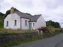
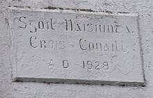
Crossconnell National School is a good example of a two classroom rural national school. The school was built in 1928, using a standard plan adapted to local conditions. The school was closed in the late 1960s with the decline in the rural population.[3]
The northern limit of the townland includes Tullagh bay, which contains a pristine and picturesque sandy beach.
References
- "Crossconnell Townland, Co. Donegal".
- "Griffith's Valuation". Ask Ireland. 28 May 2020.
- "National Inventory of Architectural Heritage".