Crooked Creek (Allegheny River tributary)
Crooked Creek is a tributary of the Allegheny River in both Armstrong and Indiana counties in the U.S. state of Pennsylvania.[1]
| Crooked Creek | |
|---|---|
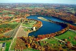 The Crooked Creek Lake Recreation Area is a dam, reservoir, and park near Ford City, Armstrong County in the U.S. state of Pennsylvania. | |
| Location | |
| Country | United States |
| Physical characteristics | |
| Source | |
| ⁃ coordinates | 40.6956207°N 79.078645°W |
| Mouth | |
⁃ coordinates | 40.7489532°N 79.5536568°W |
⁃ elevation | 771 ft (235 m) |
| Basin features | |
| River system | Allegheny River |
Several covered bridges span the stream and its tributaries in Indiana County. The Thomas Covered Bridge crosses Crooked Creek in Armstrong Township.[2] The Harmon's Covered Bridge crosses the South Branch Plum Creek and the Trusal Covered Bridge crosses Plum Creek, tributaries of Crooked Creek, in Washington Township.[3]
Course
Crooked Creek joins the Allegheny River in both Bethel and Manor townships.
Tributaries
(Mouth at the Allegheny River)
- Campbell Run[4]
- Elbow Run[5]
- Horney Camp Run[6]
- Coal Bank Run[7]
- Beers Run[8]
- Pine Run[9]
- Cherry Run[10]
- North Branch Cherry Run[11]
- Fagley Run[12]
- Long Run[13]
- Sugar Run[14]
- Lindsay Run[15]
- Craig Run[16]
- Gobblers Run[17]
- Plum Creek[18]
- Walker Run[28]
- Anthony Run[29]
- Curry Run[30]
- Cheese Run[31]
- Mitchell Run[32]
- Dark Hollow Run[33]
- Fulton Run[34]
- McKee Run[35]
- Twomile Run[36]
- Pine Run[37]
- Brush Run[38]
- Rayne Run[39]
Political subdivisions
Crooked Creek traverses the following political subdivisions, named in order they are first encountered traveling downstream:
- Rayne Township, Indiana County
- Washington Township, Indiana County
- Creekside
- White Township, Indiana County
- Armstrong Township, Indiana County
- Plumcreek Township, Armstrong County
- South Bend Township, Armstrong County
- Burrell Township, Armstrong County
- Bethel Township, Armstrong County
- Kittanning Township, Armstrong County
- Manor Township, Armstrong County
References
- "Crooked Creek". Geographic Names Information System. United States Geological Survey. Retrieved 2010-06-22.
- "National Historic Landmarks & National Register of Historic Places in Pennsylvania" (Searchable database). CRGIS: Cultural Resources Geographic Information System. Note: This includes Susan M. Zacher (n.d.). "National Register of Historic Places Inventory Nomination Form: Covered Bridges of Indiana County (Thomas Covered Bridge)" (PDF). Retrieved 2011-12-04.
- "National Historic Landmarks & National Register of Historic Places in Pennsylvania" (Searchable database). CRGIS: Cultural Resources Geographic Information System. Note: This includes Susan M. Zacher (n.d.). "National Register of Historic Places Inventory Nomination Form: Covered Bridges of Indiana County (Harmon's Covered Bridge)" (PDF). Retrieved 2011-12-04. and Susan M. Zacher (n.d.). "National Register of Historic Places Inventory Nomination Form: Covered Bridges of Indiana County (Trusal Covered Bridge)" (PDF). Retrieved 2011-12-04.
- "Campbell Run, Armstrong County, Pennsylvania". Geographic Names Information System. United States Geological Survey.
- "Elbow Run, Armstrong County, Pennsylvania". Geographic Names Information System. United States Geological Survey.
- "Horney Camp Run, Armstrong County, Pennsylvania". Geographic Names Information System. United States Geological Survey.
- "Coal Bank Run, Armstrong County, Pennsylvania". Geographic Names Information System. United States Geological Survey.
- "Beers Run, Armstrong County, Pennsylvania". Geographic Names Information System. United States Geological Survey.
- "Pine Run, Armstrong County, Pennsylvania". Geographic Names Information System. United States Geological Survey.
- "Cherry Run, Armstrong County, Pennsylvania". Geographic Names Information System. United States Geological Survey.
- "North Branch Cherry Run, Armstrong County, Pennsylvania". Geographic Names Information System. United States Geological Survey.
- "Fagley Run, Armstrong County, Pennsylvania". Geographic Names Information System. United States Geological Survey.
- "Long Run, Armstrong County, Pennsylvania". Geographic Names Information System. United States Geological Survey.
- "Sugar Run, Armstrong County, Pennsylvania". Geographic Names Information System. United States Geological Survey.
- "Lindsay Run, Armstrong County, Pennsylvania". Geographic Names Information System. United States Geological Survey.
- "Craig Run, Armstrong County, Pennsylvania". Geographic Names Information System. United States Geological Survey.
- "Gobblers Run, Armstrong County, Pennsylvania". Geographic Names Information System. United States Geological Survey.
- "Plum Creek, Armstrong County, Pennsylvania". Geographic Names Information System. United States Geological Survey.
- "Dutch Run, Armstrong County, Pennsylvania". Geographic Names Information System. United States Geological Survey.
- "Cessna Run, Armstrong County, Pennsylvania". Geographic Names Information System. United States Geological Survey.
- "South Branch Plum Creek, Armstrong County, Pennsylvania". Geographic Names Information System. United States Geological Survey.
- "Mudlick Run, Indiana County, Pennsylvania". Geographic Names Information System. United States Geological Survey.
- "Sugarcamp Run, Indiana County, Pennsylvania". Geographic Names Information System. United States Geological Survey.
- "Reddings Run, Indiana County, Pennsylvania". Geographic Names Information System. United States Geological Survey.
- "Leisure Run, Indiana County, Pennsylvania". Geographic Names Information System. United States Geological Survey.
- "Goose Run, Indiana County, Pennsylvania". Geographic Names Information System. United States Geological Survey.
- "North Branch Plum Creek, Armstrong County, Pennsylvania". Geographic Names Information System. United States Geological Survey.
- "Walker Run, Indiana County, Pennsylvania". Geographic Names Information System. United States Geological Survey.
- "Anthony Run, Indiana County, Pennsylvania". Geographic Names Information System. United States Geological Survey.
- "Curry Run, Indiana County, Pennsylvania". Geographic Names Information System. United States Geological Survey.
- "Cheese Run, Indiana County, Pennsylvania". Geographic Names Information System. United States Geological Survey.
- "Mitchell Run, Indiana County, Pennsylvania". Geographic Names Information System. United States Geological Survey.
- "Dark Hollow Run, Indiana County, Pennsylvania". Geographic Names Information System. United States Geological Survey.
- "Fulton Run, Indiana County, Pennsylvania". Geographic Names Information System. United States Geological Survey.
- "McKee Run, Indiana County, Pennsylvania". Geographic Names Information System. United States Geological Survey.
- "Twomile Run, Indiana County, Pennsylvania". Geographic Names Information System. United States Geological Survey.
- "Pine Run, Indiana County, Pennsylvania". Geographic Names Information System. United States Geological Survey.
- "Brush Run, Indiana County, Pennsylvania". Geographic Names Information System. United States Geological Survey.
- "Rayne Run, Indiana County, Pennsylvania". Geographic Names Information System. United States Geological Survey.
External links
This article is issued from Wikipedia. The text is licensed under Creative Commons - Attribution - Sharealike. Additional terms may apply for the media files.