Corrientes
Corrientes (Spanish pronunciation: [koˈrjentes] (![]()
Corrientes | |
|---|---|
 (From top to bottom; from left to right) Skyline on Paraná River; General Belgrano Bridge; Government House courtyard; San Martin Palace and Cabral Square. | |
 Flag  Coat of arms | |
 | |
 Corrientes Location of Corrientes in Argentina | |
| Coordinates: AR_type:city 27°29′S 58°49′W | |
| Country | |
| Province | |
| Department | Capital |
| Government | |
| • Mayor | Roberto Fabían Ríos (Front for Victory) |
| Area | |
| • City | 500 km2 (200 sq mi) |
| Elevation | 52 m (171 ft) |
| Population (2010 census) | |
| • Urban | 346,334 |
| Demonym(s) | correntino/a |
| Time zone | UTC−3 (ART) |
| CPA base | W3400 |
| Dialing code | +54 379 |
| Website | Official website |
It has a mix of colonial and modern architecture, several churches and a number of lapacho, ceibo, jacaranda and orange trees. It is also home to one of the biggest carnival celebrations in the country.
The annual average temperature is 20 °C (68 °F), with maximum and minimum averages of 45 and 5 °C (113 and 41 °F) respectively. The annual rainfall is around 1,200 millimetres (47 in).
Transportation
The General Belgrano Bridge crosses the Paraná River that serves as the natural border with the neighbouring Chaco Province. On the other side of the bridge is Resistencia, capital of Chaco. To the west and up the Paraná, between Paraguay and Argentina, lies the Yaciretá dam, one of the largest hydroelectric power generators in the world.
The Doctor Fernando Piragine Niveyro International Airport (IATA: CNQ, ICAO: SARC) at coordinates 27°26′20″S 58°46′03″W, 5 km (3 mi) away from the city, serves the city.
The Ferrocarril Económico Correntino narrow gauge railway line to Mburucuyá operated from 1912 until 1927.
History
In 1516 Juan Díaz de Solís commanded the first expedition to reach the area populated mainly by Guaraní aboriginals, but his expedition was attacked and Solís perished in the adventure.
Sebastian Cabot established in 1527 the Sancti Spiritu fort upstream of the Paraná River, and in 1536 Pedro de Mendoza reached further north into the basin of the river, searching for the Sierras of Silver.
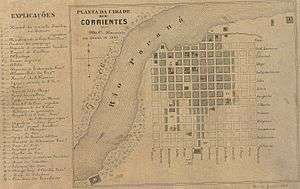
Juan Torres de Vera y Aragón founded on April 3, 1588 San Juan de Vera de las Siete Corrientes ("Saint John of Vera of the Seven Currents"), which was later shortened to Corrientes. The "seven currents" refer to the seven peninsulas on the shore of the river at this place, that produced wild currents that made difficult the navigation of the river through this part.
Nevertheless, its position between Asunción - in present Paraguay - and Buenos Aires made it an important middle point, especially because of its 55-metre-high lands that prevent flooding when the water level rises.
In 1615 Jesuits settled near the Uruguay River. In 1807 the city resisted the British invasions. During the Argentine War of Independence it was in permanent conflict with the centralist government of Buenos Aires, but the Paraguayan War united them after the city was attacked by Paraguayan forces in 1865.
Climate
The annual average temperature is 21 °C (70 °F), with maximum and minimum averages of 45 and 5 °C (113 and 41 °F) respectively. The annual rainfall is around 1,200 millimetres (47 in). The Köppen Climate Classification subtype for this climate is "Cfa" (Humid Subtropical Climate).[1] Frosts are rare; with the dates of the first and last frost being July 5 and July 12 respectively, indicating that most of the year is frost free.[2] The highest temperature recorded was 42.4 °C (108.3 °F) on November 15, 1985 while the lowest temperature recorded was −2.8 °C (27.0 °F) on June 15, 1979.[3]
| Climate data for Corrientes Airport (1981–2010, extremes 1962–present) | |||||||||||||
|---|---|---|---|---|---|---|---|---|---|---|---|---|---|
| Month | Jan | Feb | Mar | Apr | May | Jun | Jul | Aug | Sep | Oct | Nov | Dec | Year |
| Record high °C (°F) | 42.0 (107.6) |
40.7 (105.3) |
39.6 (103.3) |
37.2 (99.0) |
34.1 (93.4) |
31.7 (89.1) |
33.0 (91.4) |
36.4 (97.5) |
40.9 (105.6) |
42.0 (107.6) |
42.4 (108.3) |
41.1 (106.0) |
42.4 (108.3) |
| Average high °C (°F) | 33.2 (91.8) |
31.9 (89.4) |
30.6 (87.1) |
26.8 (80.2) |
23.4 (74.1) |
21.0 (69.8) |
21.1 (70.0) |
23.4 (74.1) |
24.9 (76.8) |
27.9 (82.2) |
29.5 (85.1) |
31.9 (89.4) |
27.1 (80.8) |
| Daily mean °C (°F) | 27.0 (80.6) |
26.0 (78.8) |
24.7 (76.5) |
21.4 (70.5) |
18.0 (64.4) |
15.9 (60.6) |
15.2 (59.4) |
17.0 (62.6) |
18.5 (65.3) |
21.8 (71.2) |
23.7 (74.7) |
25.8 (78.4) |
21.3 (70.3) |
| Average low °C (°F) | 21.3 (70.3) |
20.8 (69.4) |
19.7 (67.5) |
16.9 (62.4) |
13.4 (56.1) |
11.6 (52.9) |
10.4 (50.7) |
11.5 (52.7) |
13.1 (55.6) |
16.3 (61.3) |
17.9 (64.2) |
20.1 (68.2) |
16.1 (61.0) |
| Record low °C (°F) | 11.8 (53.2) |
11.0 (51.8) |
7.2 (45.0) |
3.9 (39.0) |
−0.4 (31.3) |
−2.8 (27.0) |
−2.0 (28.4) |
−1.3 (29.7) |
0.5 (32.9) |
2.8 (37.0) |
7.2 (45.0) |
8.3 (46.9) |
−2.8 (27.0) |
| Average precipitation mm (inches) | 167.3 (6.59) |
161.9 (6.37) |
175.1 (6.89) |
206.6 (8.13) |
91.9 (3.62) |
70.5 (2.78) |
37.5 (1.48) |
47.2 (1.86) |
75.7 (2.98) |
150.7 (5.93) |
184.3 (7.26) |
157.7 (6.21) |
1,526.4 (60.09) |
| Average precipitation days (≥ 0.1 mm) | 8.5 | 9.4 | 8.6 | 10.2 | 7.5 | 8.4 | 6.1 | 5.7 | 8.1 | 10.4 | 10.0 | 9.3 | 102.2 |
| Average relative humidity (%) | 70.7 | 74.6 | 77.7 | 80.2 | 80.0 | 81.2 | 76.5 | 72.3 | 70.8 | 72.3 | 72.1 | 70.9 | 74.9 |
| Mean monthly sunshine hours | 279.0 | 243.6 | 232.5 | 204.0 | 201.5 | 171.0 | 186.0 | 192.2 | 195.0 | 244.9 | 261.0 | 291.4 | 2,702.1 |
| Percent possible sunshine | 66 | 67 | 61 | 59 | 60 | 54 | 57 | 55 | 54 | 62 | 65 | 67 | 61 |
| Source 1: Servicio Meteorológico Nacional[4][3] | |||||||||||||
| Source 2: NOAA (sun 1961–1990)[5] | |||||||||||||
In fiction
The Graham Greene spy novel The Honorary Consul (1973) takes place in Corrientes.
Gallery
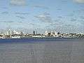 View of the Corrientes waterfront
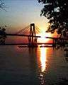 The Belgrano Bridge
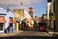 A pastel-hued street near downtown Corrientes
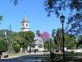 May 25 square, Corrientes
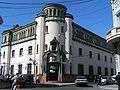 The Provincial Ministry of the Economy
 River otter and toy, Corrientes Zoo
References
- Climate Summary for Corrientes
- "Corrientes, Corrientes". Estadísticas meteorológicas decadiales (in Spanish). Oficina de Riesgo Agropecuario. Retrieved June 12, 2015.
- "Clima en la Argentina: Guia Climática por Corrientes Aero". Caracterización: Estadísticas de largo plazo (in Spanish). Servicio Meteorológico Nacional. Archived from the original on September 4, 2017. Retrieved October 4, 2017.
- "Estadísticas Climatológicas Normales - período 1981-2010" (in Spanish). Servicio Meteorológico Nacional. Retrieved January 20, 2018.
- "Corrientes AERO Climate Normals 1961–1990". National Oceanic and Atmospheric Administration. Retrieved March 29, 2015.
External links
- Municipality of Corrientes – official website MCC (in Spanish)
- Municipal information: Municipal Affairs Federal Institute (IFAM), Municipal Affairs Secretariat, Ministry of Interior, Argentina. (in Spanish)
- Sights (English)
- Map
| Authority control |
|
|---|