Corozal Town
Corozal Town is a town in Belize, capital of Corozal District. Corozal Town is located about 84 miles north of Belize City, and 9 miles from the border with Mexico. The population of Corozal Town, according to the main results of the 2010 census, is 9,871. Corozal was a private estate before becoming a town in the 1840s, mostly settled by Maya Mestizo refugees from the Caste War of Yucatán. Much of the town was built over an ancient Maya city, sometimes known as Santa Rita; this may have been the original Pre-Columbian town called Chetumal. Corozal Town was badly damaged by Hurricane Janet in 1955, and was substantially rebuilt afterwards.
Corozal Town | |
|---|---|
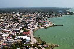 Aerial of Corozal Town | |
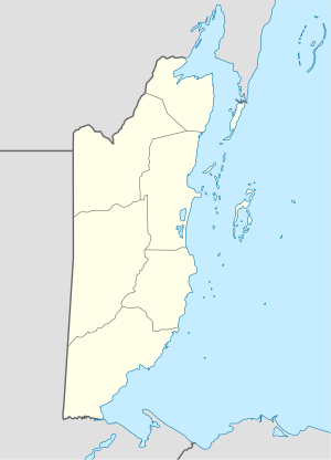 Corozal Town Map of Corozal metropolitan area | |
| Coordinates: 18°24′N 88°24′W | |
| Country | |
| District | Corozal |
| Constituency | Corozal Bay, Corozal North |
| Government | |
| • Mayor | Rigo Vellos (PUP) |
| Elevation | 0 m (0 ft) |
| Population (2010)[1] | |
| • Total | 10,287 |
| • Estimate (2017)[2] | 13,502 |
| Demonym(s) | Corozaleño(a) |
| Time zone | UTC-6 (Central) |
| Climate | Aw |
| Website | corozal |
History
Corozal, the northmost town in Belize, was founded in 1848 by refugees from the Maya Indian uprising against the Spanish in neighbouring Yucatán. This uprising, known as the Caste War of Yucatán (from the Spanish "castas" or race), began as a war against the Spaniards, but it eventually became a war against the Mestizos. The Mestizos, half Spanish and half Indian, had proved to be formidable allies of the Spaniards, and were thus mortal enemies of the Maya Indians.
A massacre at Bacalar, Mexico — a Mestizo stronghold about thirty miles north of Corozal Town — finally led to the exodus of thousands of Mestizos from Bacalar and the surrounding area. Between 1848 and 1856 more than 10,000 refugees crossed the Rio Hondo, the river that now serves as a boundary between Belize and Mexico. These immigrants sought refuge in northern Belize, and increased the population of Corozal Town to 4500. Mr. James Blake, a magistrate, let them settle on lands in the Corozal District and helped them to establish the new crop — sugar cane.
The Mestizo refugees were far from safe in Corozal Town as the Maya Indians from the Mexican base in Santa Cruz Bravo — today Carrillo Puerto — made several incursions in Corozal Town. In defense, Corozal became a garrison town and Fort Barlee was built here in 1870. Today, the brick corner supports of the fort surround the post office complex of the buildings across from the central town square.
The immigrants brought with them Maya Mestizo culture: Spanish and Yucatec Maya language, Catholicism and Maya folklore, the use of alcalde, their family structure and way of life. Soon, there emerged a local replication of the society of the Yucatán within the boundaries of a country ruled by English expatriates.
Across the bay from Corozal Town are the mounds of Cerros, the first Maya coastal trading centre. Cerros is considered one of the most important late preclassic Maya sites because it represented the first experiment with kingship in the Maya world. The remains include a number of temples, plazas, ballcourts, canals, and minor structures. The most interesting artifacts so far discovered are the five jade head pendants.
Within Corozal itself can be found another Maya ruin from the fourteenth century AD. Known as Santa Rita, the pyramid site sits atop the remains of a Maya city that dominated the area for more, than 2000 years. Burial sites rich in jewelry and artifacts have recently been unearthed here. Santa Rita was probably part of ancient Chactumal, the Maya capital of the area at the time of the first Spanish attempt to conquer the Yucatec Mayas in the early 16th century. The ruins of Santa Rita is located near the town's Hospital and is surrounded by the villages of San Andres, San Antonio, and Paraiso, by walking distances. An estimated 90% of the town was destroyed by Hurricane Janet in 1955, and most of the present structures post-date that hurricane.
The town is served by Corozal Hospital.
Climate
| Climate data for Corozal Town (1981–2010) | |||||||||||||
|---|---|---|---|---|---|---|---|---|---|---|---|---|---|
| Month | Jan | Feb | Mar | Apr | May | Jun | Jul | Aug | Sep | Oct | Nov | Dec | Year |
| Average high °C (°F) | 28.3 (82.9) |
30.3 (86.5) |
31.6 (88.9) |
32.8 (91.0) |
33.1 (91.6) |
32.8 (91.0) |
32.6 (90.7) |
32.7 (90.9) |
33.0 (91.4) |
31.7 (89.1) |
29.9 (85.8) |
28.7 (83.7) |
31.5 (88.7) |
| Daily mean °C (°F) | 22.8 (73.0) |
24.5 (76.1) |
25.4 (77.7) |
26.7 (80.1) |
28.1 (82.6) |
28.3 (82.9) |
28.0 (82.4) |
27.9 (82.2) |
27.8 (82.0) |
26.6 (79.9) |
24.7 (76.5) |
23.5 (74.3) |
26.2 (79.2) |
| Average low °C (°F) | 17.3 (63.1) |
18.7 (65.7) |
19.1 (66.4) |
20.7 (69.3) |
23.0 (73.4) |
23.8 (74.8) |
23.4 (74.1) |
23.2 (73.8) |
22.7 (72.9) |
21.6 (70.9) |
19.5 (67.1) |
18.2 (64.8) |
20.9 (69.6) |
| Average precipitation mm (inches) | 58.5 (2.30) |
31.9 (1.26) |
32.1 (1.26) |
45.7 (1.80) |
107.5 (4.23) |
216.8 (8.54) |
140.4 (5.53) |
172.6 (6.80) |
195.7 (7.70) |
193.7 (7.63) |
95.5 (3.76) |
64.8 (2.55) |
1,355.2 (53.36) |
| Average precipitation days (≥ 1.0 mm) | 7 | 4 | 3 | 3 | 6 | 13 | 11 | 12 | 13 | 12 | 9 | 7 | 100 |
| Source: National Meteorological Service of Belize[3] | |||||||||||||
Population and Housing
According to the 2010 Population and Housing Census the town of Corozal has a total population of 9,871; 4,740 male and 5,131 female. The total number of households is 2,672 and the average household size is 3.7.
Language
Most spoken language in Corozal is Spanish.
Image gallery
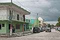 Corozal Town street on a gloomy day
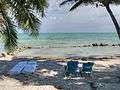 Corozal limestone beach
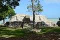 Cerros Ruins
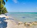 Another view of Corozal limestone beach
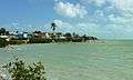 Corozal seafront
 Corozal Town Park
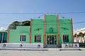 Corozal Town Hall
 Corozal Town square
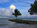 A storm looms off the Corozal coastline opposite the setting sun
Future plans
Corozal Town will have radio telescope named after him, Wernher von Braun Observatory which is owned by NASA.
References
- "Belize Population and Housing Census 2010" (PDF). Statistical Institute of Belize. 2013. Archived from the original (PDF) on 27 January 2016. Retrieved 14 May 2016.
- "Mid-Year Population Estimates by Area and Sex 2008 - 2015". Statistical Institute of Belize. Retrieved 14 May 2016.
- "Climatology Information for a few stations across Belize". National Meteorological Service of Belize. Retrieved 2 August 2016.
External links
| Wikimedia Commons has media related to Corozal, Belize. |
| Wikivoyage has a travel guide for Corozal Town. |