Corona Satellite Calibration Targets
The Corona Satellite Calibration Targets consist of 272 concrete markers embedded into the Earth's surface in and around Casa Grande, Arizona, United States.[1] The markers were used to aid camera calibration for the US Central Intelligence Agency's Corona spy satellite program.[2] The markers formed a square 16-by-16-mile (26 by 26 km) grid, and were maintained from 1959 to 1972. Some of the original markers can still be found on Google satellite maps and ground inspection. See links to maps below.
Corona Satellite Calibration Targets | |
|---|---|
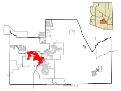 Location in Pinal County and the US state of Arizona |
Background
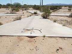
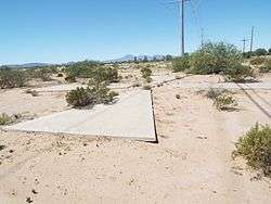
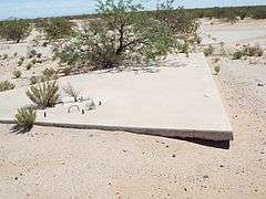
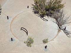
Following the launch of Corona satellites in the 1960s, the US National Foreign Intelligence Program determined that there was a need for calibration under the Controlled Range Network. Working with the Arizona Real Estate Office, the US Army Map Service was directed to lease land for office space in Casa Grande, Arizona. Land was leased in 100-by-100-foot (30 by 30 m) parcels, with access to a road. Large concrete Maltese crosses in the ground, each 60 feet (18 m) in width, were in place by 1967. The crosses were arranged in a 16-by-16-mile (26 by 26 km) grid.[2][3][4][5]
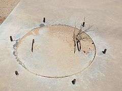
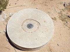
Each of the targets has a manhole on the west arm of the cross, the manhole has a cement cover and steel reinforcement bars. According to Gary Morgan, member of the Cold War Museum in Warrenton, Virginia, the six pieces of rebar, which protrude at an equal distance from each other, may have been used to hold a laser designator to provide the Corona satellites a more accurate fix on each target.[2]
The majority of the targets were abandoned when the program ended in 1972. By the late-1970s, the US Army Map Service considered the targets to be obsolete for their use due the land on which they were situated had subsided because of groundwater extraction.[2] Land lessees were then given the option of having the targets removed and dumped near Eloy, Arizona. As of 2013, at least 143 targets remain in place, unless they have been removed because the location has been redeveloped.[2]
Images
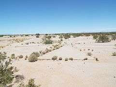
The Corona Satellite Calibration Targets pictured in the image gallery are two of the few remaining ones in the Sonoran Desert. The first one is located on the southeast corner of South Montgomery and West Cornman Roads. The second one is located on the northeast corner of West Cornman Road and Carmel Boulevard.
|

References
| Wikimedia Commons has media related to Corona Satellite Calibration Targets. |
- Destination Strange
- "Corona Test Targets". borntourist.com. Retrieved 29 March 2020.
- Manaugh, Geoff (8 April 2014). "Zooming-In On Satellite Calibration Targets in the Arizona Desert". Atlas Obscura. Retrieved 14 April 2016.
- Hider, Anna (3 October 2014). "What the heck are these abandoned cement targets in the Arizona desert?". Roadtrippers. Retrieved 14 April 2016.
- "NRO - Declassified Records". www.nro.gov. National Reconnaissance Office. Archived from the original on 27 April 2016. Retrieved 19 April 2016.
Links
- All Corona Satellite Calibration Targets - Google map of the locations of all targets, identified as Present, Damaged, or Missing.
- Remaining Corona Satellite Calibration Targets — Google map of 145 remaining markers which formed a grid, used from 1959 to 1972 to calibrate the Corona spy satellite cameras, by Andrei Conovaloff, 2018.
- 3 online reports, Arizona Republic, July 2, 2016. — "Corona spy satellite timeline"; "How Casa Grande crosses calibrated spy-satellite camera"; "How Casa Grande crosses helped fight the Cold War".
- NPR, National Public Radio, October 11, 2016. - "Decades-Old Mystery Put To Rest: Why Are There X's In The Desert?"
- All points in OpenStreetMap