Corn Islands
The Corn Islands (Spanish: Las Islas del Maíz) are two islands about 70 kilometres (43 mi) east of the Caribbean coast of Nicaragua, constituting one of 12 municipalities of the South Caribbean Coast Autonomous Region. The official name of the municipality is Corn Island (the English name is officially used in Spanish-speaking Nicaragua).
Corn Island Corn Island | |
|---|---|
Municipality | |
.png) Map of the Corn Islands | |
| Motto(s): The Eden of the Caribbean of Nicaragua | |
| Anthem: Corn Island song | |
 Corn Island Location in Nicaragua  Corn Island Corn Island (Caribbean) | |
| Coordinates: 12°10′N 83°02′W | |
| Country | |
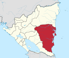
| Department | South Caribbean Coast Autonomous Region |
| Founded by | British |
| Seat | Brig Bay |
| Government | |
| • Type | Mayor-council government |
| • Mayor | Cleaveland Webster (Frente Sandinista de Liberación Nacional) |
| Area | |
| • Total | 5.0 sq mi (12.9 km2) |
| Elevation | 371 ft (113 m) |
| Population (2005) | |
| • Total | 7,429 |
| Time zone | Central Standard Time |
| Area code(s) | +505 |
| Website | www.discovercornisland.com |
History
The Corn Islands, along with the eastern half of present-day Nicaragua, were a British protectorate from 1655 until 1860, a period when the region was called the Mosquito Coast. At one time, the islands were frequented by Caribbean pirates. The Nicaraguan government annexed the region in 1894.
Under the Bryan–Chamorro Treaty of 1914, the islands were leased to the United States for a period of 99 years. The terms of the lease made the Corn Islands subject to the sovereignty of the United States.[1] The lease notwithstanding, the United States never maintained a significant presence in the islands. The right of the United States to use of the islands remained until April 25, 1971, when the lease was officially terminated by the denunciation of the Bryan–Chamorro Treaty on July 14, 1970, under the presidency of Anastasio Somoza Debayle.[2]
Geography
The Corn Islands consist of the Big Corn Island (Isla Grande del Maíz; often simply referred to as Corn Island; Isla del Maíz), with an area of 10 square kilometres (3.9 sq mi), and Little Corn Island (Isla Pequeña del Maíz), with an area of 2.9 square kilometres (1.1 sq mi). The total area is 12.9 square kilometres (5.0 sq mi). Mount Pleasant Hill in the north of Big Corn Island, is the highest elevation of the islands, at 113 metres (371 ft). Little Corn Island reaches a height of 38 metres (125 ft) at Lookout Point in the northern part of the island.
Climate
According to the Köppen climate classification, the nearby mainland region of Bluefields features a tropical rainforest climate (Köppen Af). There is a drier period from February to April, but the trade winds ensure that unlike the Pacific coast of Nicaragua, rain still falls frequently during this period. For the rest of the year when tropical low pressure dominates rainfall is extremely heavy, helped by the coast being shaped in such a manner as to intercept winds from the south as prevail during the northern summer.
| Climate data for Corn Islands, Nicaragua | |||||||||||||
|---|---|---|---|---|---|---|---|---|---|---|---|---|---|
| Month | Jan | Feb | Mar | Apr | May | Jun | Jul | Aug | Sep | Oct | Nov | Dec | Year |
| Average high °C (°F) | 27.8 (82.0) |
28.4 (83.1) |
29.0 (84.2) |
29.8 (85.6) |
29.9 (85.8) |
28.9 (84.0) |
28.1 (82.6) |
28.5 (83.3) |
29.1 (84.4) |
28.8 (83.8) |
28.4 (83.1) |
28.0 (82.4) |
28.7 (83.7) |
| Daily mean °C (°F) | 24.9 (76.8) |
25.2 (77.4) |
26.2 (79.2) |
27.0 (80.6) |
27.0 (80.6) |
26.0 (78.8) |
25.6 (78.1) |
25.6 (78.1) |
25.8 (78.4) |
25.6 (78.1) |
25.3 (77.5) |
25.2 (77.4) |
25.8 (78.4) |
| Average low °C (°F) | 22.2 (72.0) |
22.3 (72.1) |
23.3 (73.9) |
23.7 (74.7) |
24.2 (75.6) |
23.9 (75.0) |
23.7 (74.7) |
23.6 (74.5) |
23.5 (74.3) |
23.1 (73.6) |
22.8 (73.0) |
22.6 (72.7) |
23.2 (73.8) |
| Average precipitation mm (inches) | 218 (8.6) |
114 (4.5) |
71 (2.8) |
101 (4.0) |
264 (10.4) |
581 (22.9) |
828 (32.6) |
638 (25.1) |
383 (15.1) |
418 (16.5) |
376 (14.8) |
328 (12.9) |
4,320 (170.2) |
| Average rainy days (≥ 1.0 mm) | 19 | 13 | 10 | 10 | 15 | 23 | 26 | 25 | 21 | 21 | 20 | 22 | 225 |
| Source: HKO[3] | |||||||||||||
Demographics
The population of the islands numbered 6,626 as of 2005 (census of population, May 28 to June 11, 2005).[4]
As of early 2009, local authorities estimate the population of Big Corn Island to be 6,200 and that of Little Corn Island to be 1,200. The distribution of tourists is estimated to be roughly 25% at Big Corn Island and 75% at Little Corn Island.
The islanders are Afro-descendant, English-speaking Creole people mixed with indigenous.
Subdivisions
The municipality of Corn Island is subdivided into six wards (barrios), five of which are on Big Corn Island, while Little Corn Island constitutes the sixth ward:
| Barrio | Population (Census May 28- June 11, 2005)[5] | Location | Villages |
|---|---|---|---|
| Brig Bay | 3,930 | west | Brig Bay |
| La Loma | 682 | south | La Loma, Long Beach, Queen Hill, Bluff Point |
| South End | 764 | east | South End, Mount Pleasant |
| Sally Peachie | 265 | northeast | Sally Peachie, Little Hill |
| North End | 490 | northwest | North End |
| Little Corn Island | 495 | island 13 km northeast | The Village, Carib Town |
| Corn Island | 6,626 |
Transportation
 | |
 Nicaragua | |
| |
| Location | Corn Island |
|---|---|
| Coordinates | 12°17′25.6″N 82°58′58.4″W |
| Foundation | concrete base |
| Construction | metal skeletal tower |
| Tower shape | square pyramidal tower with balcony and light |
| Markings / pattern | white tower |
| Tower height | ~ 15 metres (49 ft) |
| Light source | solar power |
| Range | 8 nautical miles (15 km; 9.2 mi) |
| Characteristic | Fl W |
| Admiralty number | J6065 |
| NGA number | 16502 |
| ARLHS number | NIC-002 |
| Managing agent | Aquatic Transport Directorate[6][7] |
Big Corn Island has a paved road about 12 kilometres (7.5 mi) long which runs the length of the island. Automobiles, motorbikes and bicycles are the primary means of transport on the island. Most cars are used as taxis and cost 30 Cordobas for each ride of an adult person. The only other public transportation option is the bus that circles the island clockwise and costs 10 cordobas.
Little Corn Island is accessible by fast boats, usually three or four times per day depending on weather from Big Corn Island, and by a small cargo ship from the port at Southwest Bay on Big Corn Island (World Port Index No. 9775). Little Corn Island has no motor vehicles. Due to its small size, all transport on the island is done on foot.
Air
The Corn Islands are about 70 kilometres (43 mi) away from Bluefields. Corn Island Airport in the city of Brig Bay is served by La Costeña airlines from Bluefields and Managua.
Sea
Big Corn Island can be reached by a cargo ship that departs two or three times per week from El Rama through Escondido River with its mouth at Bluefields. These ships usually do not have much passenger room, and the trip may last 12 hours. From Bluefields passengers may also use a once-a-week government ferry, a trip of around 5 hours. The Isla Pequeña del Maiz Lighthouse is on Little Corn Island.
Economy and tourism
Throughout most of the 20th century, the economy revolved around coconut production. During the 1960s and 1970s, commercial fishing as well as lobster and shrimp fishing, became the main industry. The recent growth in tourism throughout the region, however, has also affected the islands. Tourism on the islands has grown considerably, with their many surrounding coral reefs making them a popular destination for scuba diving and snorkeling.
Barracudas, nurse sharks, hammerhead sharks, green sea turtles, and spotted eagle rays are among the marine life that can be seen around the islands.
Sports
Baseball is a popular sport in the Corn Islands. The main stadium on the island is the Karen Tucker Baseball Stadium.
Notable people
- Cheslor Cuthbert, professional baseball player for the Kansas City Royals
See also
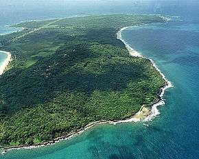
 Coast of Little Corn Island
- Aerial view of Corn Island
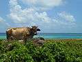 Caribbean Cow
References
- Treaties and Other International Agreements of the United States of America, 1776-1949: Nepal-Peru, p. 379
- "Formerly Disputed islands". Office of Insular Affairs, U.S. Department of the Interior. Retrieved 2015-06-09.
- "Climatological Normals of Bluefields, Nicaragua". Hong Kong Observatory. Retrieved 2012-03-13.
- "POBLACION VOLUMEN" (PDF). Archived from the original (PDF) on 20 March 2009. Retrieved 18 July 2014.
- VIII CENSO DE POBLACIÒN Y IV DE VIVIENDA, 2005 Archived 2009-03-20 at the Wayback Machine
- Nicaragua Caribbean Coast The Lighthouse Directory. University of North Carolina at Chapel Hill. Retrieved 23 January 2017
- List of Lights, Pub. 110: Greenland, The East Coasts of North and South America (Excluding Continental U.S.A. Except the East Coast of Florida) and the West Indies (PDF). List of Lights. United States National Geospatial-Intelligence Agency. 2016.
External links
| Wikimedia Commons has media related to Corn Islands. |
| Wikivoyage has a travel guide for Big Corn Island. |
| Wikivoyage has a travel guide for Little Corn Island. |
- RightSide Guide: The survival guide to the Caribbean coast of Nicaragua
- BigCornIsland.com Tourism on the Corn Islands
- 2007 trip report
- Bluefields and Corn Island, a history written by Maureen Tweedy
- LittleCornIsland.net About Little Corn Island
Corn Island Travel Guide
Capital: Bluefields | ||
| Municipalities |
|  |
| |
| |
| |
| |
|