Cordillera Domeyko
The Cordillera Domeyko is a mountain range of the Andes located in northern Chile, west of Salar de Atacama. It runs north-south for approximately 600 km,[1] parallel to the main chain. The mountain range marks the eastern border of the flat parts of Atacama Desert.
| Cordillera Domeyko | |
|---|---|
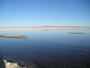 Cerro Quimal in the distance | |
| Highest point | |
| Peak | Cerro Quimal |
| Elevation | 4,278 m (14,035 ft) |
| Coordinates | 23°7′S 68°40′W |
| Dimensions | |
| Length | 600 km (370 mi) north-south |
| Geography | |
| Country | Chile |
| Range coordinates | 24°30′S 69°00′W |
| Parent range | Central Andes |
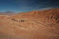
Cordillera de la Sal, part of Cordillera Domeyko. In the distance can be seen Licancabur and Juriques.
Cordillera Domeyko was named after Ignacy Domeyko and is the world's lowest humidity mountain range.[2]
External links
- Virtual Tour on 360° of Cordillera de la Sal Chilexplora.com
References
- Muñoz, N., Charrier, R. and Jordan, T. (July 2002). "Interactions between basement and cover during the evolution of the Salar de Atacama Basin, northern Chile". Revista Geológica de Chile. 29 (1): 55–80. doi:10.4067/S0716-02082002000100004.CS1 maint: multiple names: authors list (link)
- ASTER's Global View from Space Archived 2008-02-22 at the Wayback Machine
This article is issued from Wikipedia. The text is licensed under Creative Commons - Attribution - Sharealike. Additional terms may apply for the media files.