Copiapó (volcano)
Copiapó, also known as Azufre, is a stratovolcano located in the Atacama Region of Chile. The volcano separates the two portions in which Nevado Tres Cruces National Park is divided. In its vicinity lies Ojos del Salado. At its summit an Inca platform can be found.[2]
| Copiapó | |
|---|---|
| Azufre | |
 Volcan Copiapó from Quebrada Villalobos | |
| Highest point | |
| Elevation | 6,052 m (19,856 ft) [1] |
| Prominence | 1,701 m (5,581 ft) [1] |
| Listing | Ultra |
| Coordinates | 27°18′21″S 69°07′51″W [1] |
| Geography | |
 Copiapó | |
| Parent range | Andes |
| Geology | |
| Mountain type | Stratovolcano |
| Last eruption | Unknown |
| Climbing | |
| First ascent | 1937 by polish climbers |
Dacitic volcanism occurred at this centre 11-7 million years ago and covered a surface of 200 square kilometres (77 sq mi). The Valle Ancho fault can be traced beneath this volcano. The main cone is formed by dacites and block and ash flows that were later intruded by dacitic porphyries, associated with hydrothermal alteration. A smaller centre formed on the northern side of the main cone, as well as thick (100–300 metres (330–980 ft)) ignimbrites in two units. A complex of lava domes lies at their southern-eastern end with more hydrothermally altered porphyric intrusions named Azufrera de Copiapo. The last activity 6-7 million years ago formed a shield overlying the lava dome complex and the San Roman dome.[3] Obsidian from this volcanic area has been found in archeological sites.[4]
The Global Volcanism Program claims that Copiapó was reported to be fumarolically active[5] by Ferdinand von Wolff 1929 who refers to Rudolph Hauthal; it also gives "Lastarria" and "Azufre" as alternative names for Copiapó.[6] Hauthal does not refer to Copiapó volcano as fumarolically active, but instead refers to Azufre and Lastarria which are volcanoes unrelated to Copiapó.[7]
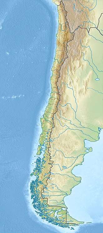
There is an Incan ruin 40 metres from the summit via north ridge. The platform is 10x6 metres and has a 4 metre wall. The summit is probably 6065 metres based on a Tandem-X study.[8]
 Maricunga Salt Flat with Copiapó Volcano in the distance
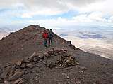 Volcan Copiapó summit showing "Inca" structures and firewood
 Incan platform at 6045 m altitude
References
- "Argentina and Chile North: Ultra-Prominences" Peaklist.org. Retrieved 2013-02-25.
- Echevarria, Evelio (2014). "Summit Archaeology" (PDF). The Alpine Journal: 193. Retrieved 28 January 2016.
- Kay, Suzanne Mahlburg; Mpodozis, Constantino; Tittler, Andrew; Cornejo, Paula (December 1994). "Tertiary Magmatic Evolution of the Maricunga Mineral Belt in Chile". International Geology Review. 36 (12): 1079–1112. doi:10.1080/00206819409465506.
- Seelenfreund, Andrea; Miranda, Javier; Dinator, María Inés; Morales, J. Roberto (December 2005). "CARACTERIZACIÓN DE OBSIDIANAS DEL NORTE Y CENTRO SUR DE CHILE MEDIANTE ANÁLISIS DE FLUORESCENCIA DE RAYOS X". Chungará (Arica) (in Spanish). 37 (2). doi:10.4067/S0717-73562005000200009.
- "Copiapó". Global Volcanism Program. Smithsonian Institution.
- Von Wolff, F (1929). Der Volcanismus II Band: Spezieller Teil 1 Teil Die Neue Welt (Pazifische Erdhalfte) der Pazifische Ozean und Seine Randgebiete (in German). Stuttgart: Ferdinand Enke. p. 828.
- Hauthal, Rudolf (1903). "Die Vulkangebiete in Chile und Argentinien". Petermanns Geographische Mitteilungen (in German). 5.
- "Andean Mountains - All above 5000m". Andes Specialists (in Portuguese). Retrieved 2020-04-07.