Connecticut Route 148
Route 148 is a state highway in southern and southeastern Connecticut running from Route 79 in Killingworth (near the Durham line) to Route 82 in the village of Hadlyme (in the town of Lyme). Route 148 crosses the Connecticut River using the Chester-Hadlyme Ferry.
| ||||
|---|---|---|---|---|
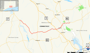 Map of southern Connecticut with Route 148 highlighted in red | ||||
| Route information | ||||
| Maintained by ConnDOT | ||||
| Length | 16.35 mi[1] (26.31 km) | |||
| Existed | 1932[2]–present | |||
| Major junctions | ||||
| West end | ||||
| East end | ||||
| Location | ||||
| Counties | Middlesex, New London | |||
| Highway system | ||||
| ||||

Route description
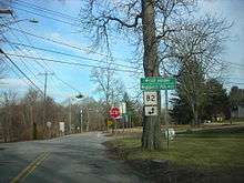
Route 148 begins as Killingworth-Durham Road at an intersection with Route 79 in northwestern Killingworth and heads southeast for 6.1 miles (9.8 km). It then turns east along Tooley Road then Chester Road as it heads towards the town of Chester. North of Killingworth center, it intersects with Route 81, about 1.9 miles (3.1 km) west of the Chester line. On entering Chester, the road becomes West Main Street, continuing eastward toward the town center. Along the way it has a junction with Route 145 (signed for the village of Winthrop) and with Route 9 (at Exit 6)before turning east northeast. In Chester center, the road becomes Water Street, which continues to an intersection with Route 154 (for Deep River and Haddam). After crossing Route 154, the road becomes Ferry Road as it runs for another 0.7 miles (1.1 km) to the Chester-Hadlyme Ferry landing on the west bank of the Connecticut River. After crossing the river into the town of Lyme, Route 148 (still known as Ferry Road) continues east through the village of Hadlyme for another 1.6 miles (2.6 km) until it ends at an intersection with Route 82.[1]
History
The Killingworth to Chester route was chartered as a turnpike in 1816 known as the Chester and North Killingworth Turnpike and ran along Chester Road and West Main Street. In 1834, an eastward extension towards the Chester-Hadlyme Ferry (then privately owned and known as Warner's Ferry) by the same turnpike company was authorized. In the same year, another company, the Hadlyme Turnpike, was chartered to build a turnpike from the Lyme side of the ferry towards the town of Salem. In 1835, still another turnpike company, the Madison and North Killingworth Turnpike, was chartered to build a road from the end of the Chester and North Killingworth Turnpike to the village of North Madison, using Tooley Road, then Abner Lane, and now abandoned roads across Lake Hammonasset. This series of turnpikes was envisioned by its proponents as part of an all-turnpike route between New Haven and Norwich. The business proved unprofitable, however, and between the years of 1842 and 1847, the various turnpike companies along the Route 148 alignment were dissolved and the roads turned over to the towns.
Modern Route 148 was established as part of the 1932 state highway renumbering and originally ran from Route 81 in Killingworth to the Hadlyme railroad station in Lyme.[2] In 1951, the eastern terminus was moved to the Chester ferry landing. In 1962, it was extended westward to Route 79 along its current alignment, and also eastward from the Hadlyme ferry landing to Route 82 (along former SR 618).[3]
Junction list
| County | Location | mi[1] | km | Destinations | Notes |
|---|---|---|---|---|---|
| Middlesex | Killingworth | 0.00 | 0.00 | ||
| 6.88 | 11.07 | ||||
| Chester | 10.27 | 16.53 | |||
| 11.93 | 19.20 | Exit 6 (Route 9) | |||
| 14.07 | 22.64 | ||||
| Connecticut River | 14.75 | 23.74 | Chester-Hadlyme Ferry (Open April 1–November 30) | ||
| New London | Lyme | 14.88 | 23.95 | SSR 431 (Geer Hill Road) – Gillette Castle State Park | |
| 16.35 | 26.31 | Eastern terminus of CT 148 | |||
| 1.000 mi = 1.609 km; 1.000 km = 0.621 mi | |||||
References
- Connecticut State Highway Log Archived 2015-07-26 at WebCite
- "Road Conditions in Connecticut". The Hartford Daily Courant. May 27, 1932. p. 14. Retrieved December 24, 2019 – via Newspapers.com.

- Connecticut Routes, Route 148
External links
| Wikimedia Commons has media related to Connecticut Route 148. |