Concepción, Paraguay
Concepción (Spanish pronunciation: [konsepˈsjon]) is a city & district in northern Paraguay and capital of the Concepción Department. It lies next to the Paraguay River.
Concepción | |
|---|---|
District & City | |
 Flag .PNG) Coat of arms | |
 Concepción | |
| Coordinates: 23°24′0″S 57°25′48″W | |
| Country | Paraguay |
| Department | Concepción |
| Concepción | 1773 for Agustín Fernando de Pinedo |
| Government | |
| • Intendente municipal | Luis Herminio Acosta Paniagua (PLRA) |
| Area | |
| • Total | 8,490 km2 (3,280 sq mi) |
| Elevation | 44 m (144 ft) |
| Population (2008) | |
| • Total | 76,378 |
| • Density | 9.0/km2 (23/sq mi) |
| Time zone | UTC-04 (AST) |
| • Summer (DST) | UTC-03 (ADT) |
| Area code(s) | 8700 |
| Climate | Aw |
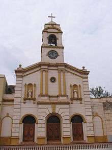
Founded by a Spanish Governor, named Agustín Fernado de Pinedo, the town prospered in the early years of the 20th century, as a centre for the north of the country, exploiting the new wealth of the Gran Chaco, and a river port. The town was also a centre for the Paraguayan Civil War of 1947. The city is the seat of the Roman Catholic Diocese of Concepción en Paraguay.
Transportation
Route 5 "Gral. Bernardino Caballero" connects the city with Pedro Juan Caballero and Asunción.
Climate
Concepción has a tropical savanna climate (Köppen: Aw) with abundant annual precipitation, although possessing a highly prominent summer peak. Summers are very hot, rainy and often oppressively humid. Severe thunderstorms are very common in the summer, and have the capability to dump copious amounts of rainfall in a short period of time, along with destructively high winds and occasional hail. Winter is much drier and considerably cooler, with near drought-like conditions often prevailing.
| Climate data for Concepción, Paraguay (1961–1990, extremes 1937–present) | |||||||||||||
|---|---|---|---|---|---|---|---|---|---|---|---|---|---|
| Month | Jan | Feb | Mar | Apr | May | Jun | Jul | Aug | Sep | Oct | Nov | Dec | Year |
| Record high °C (°F) | 41.6 (106.9) |
41.0 (105.8) |
40.0 (104.0) |
38.2 (100.8) |
35.0 (95.0) |
34.8 (94.6) |
36.2 (97.2) |
38.4 (101.1) |
40.8 (105.4) |
41.8 (107.2) |
42.6 (108.7) |
41.4 (106.5) |
42.6 (108.7) |
| Average high °C (°F) | 33.4 (92.1) |
33.2 (91.8) |
32.2 (90.0) |
29.3 (84.7) |
26.6 (79.9) |
24.3 (75.7) |
25.1 (77.2) |
26.5 (79.7) |
27.8 (82.0) |
30.7 (87.3) |
32.0 (89.6) |
32.6 (90.7) |
29.5 (85.1) |
| Daily mean °C (°F) | 27.6 (81.7) |
27.3 (81.1) |
26.2 (79.2) |
23.5 (74.3) |
20.3 (68.5) |
18.5 (65.3) |
18.7 (65.7) |
20.0 (68.0) |
21.8 (71.2) |
24.5 (76.1) |
26.0 (78.8) |
27.2 (81.0) |
23.5 (74.3) |
| Average low °C (°F) | 22.7 (72.9) |
22.5 (72.5) |
21.3 (70.3) |
18.5 (65.3) |
15.9 (60.6) |
13.8 (56.8) |
13.3 (55.9) |
14.3 (57.7) |
16.1 (61.0) |
18.6 (65.5) |
20.2 (68.4) |
21.7 (71.1) |
18.2 (64.8) |
| Record low °C (°F) | 12.5 (54.5) |
12.0 (53.6) |
8.0 (46.4) |
5.3 (41.5) |
2.5 (36.5) |
0.0 (32.0) |
−1.5 (29.3) |
−3.0 (26.6) |
1.8 (35.2) |
5.7 (42.3) |
10.0 (50.0) |
11.4 (52.5) |
−3.0 (26.6) |
| Average precipitation mm (inches) | 152.8 (6.02) |
122.8 (4.83) |
140.1 (5.52) |
122.9 (4.84) |
124.8 (4.91) |
62.3 (2.45) |
42.6 (1.68) |
55.8 (2.20) |
67.7 (2.67) |
124.7 (4.91) |
161.8 (6.37) |
163.5 (6.44) |
1,341.8 (52.83) |
| Average precipitation days (≥ 0.1 mm) | 10 | 9 | 8 | 7 | 7 | 7 | 5 | 6 | 7 | 8 | 8 | 10 | 92 |
| Average relative humidity (%) | 69 | 73 | 74 | 76 | 77 | 77 | 72 | 70 | 68 | 67 | 67 | 70 | 72 |
| Mean monthly sunshine hours | 224 | 213 | 217 | 184 | 182 | 152 | 183 | 156 | 173 | 208 | 222 | 222 | 2,336 |
| Source 1: NOAA (July, November, and December record highs, and March, April, May, August, and October record lows),[1] Meteo Climat (record highs and lows)[2] | |||||||||||||
| Source 2: Deutscher Wetterdienst (sun)[3][lower-alpha 1] | |||||||||||||
Notes
- Station ID for Concepción is 86134 Use this station ID to locate the sunshine duration
References
- "Concepción Climate Normals 1961–1990". National Oceanic and Atmospheric Administration. Retrieved March 9, 2015.
- "Station Concepción" (in French). Meteo Climat. Retrieved 15 June 2016.
- "Station 86134: Concepción". Global station data 1961–1990—Sunshine Duration. Deutscher Wetterdienst. Archived from the original on 17 October 2017. Retrieved 1 May 2015.
Sources
| Wikivoyage has a travel guide for Concepción (Paraguay). |
- World Gazeteer: Paraguay – World-Gazetteer.com