Colorado State Highway 47
State Highway 47 (SH 47) is a 4.635 mi (7.5 km) long state highway in the U.S. state of Colorado. The western terminus is at Interstate 25 (I-25), U.S. Route 50 (US 50), US 85 and US 87 in Pueblo, and the eastern terminus is at US 50 and SH 96 in Pueblo.
| ||||
|---|---|---|---|---|
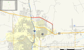 Map of Pueblo County in south central Colorado with SH 47 highlighted in red | ||||
| Route information | ||||
| Maintained by CDOT | ||||
| Length | 4.635 mi[1] (7.459 km) | |||
| Major junctions | ||||
| West end | ||||
| East end | ||||
| Location | ||||
| Counties | Pueblo | |||
| Highway system | ||||
Colorado State Highways
| ||||

Route description
SH 47 runs 4.6 miles (7.4 km), starting at I-25 exit 101 on the north end of Pueblo then east and south to a junction with US 50 and SH 96.
Major intersections
The entire route is in Pueblo, Pueblo County. All exits are unnumbered.
| mi | km | Destinations | Notes | ||
|---|---|---|---|---|---|
| 0.000 | 0.000 | Western terminus; I-25 exit 101 | |||
| Frontage Road | Eastbound exit only; access to Pueblo Mall | ||||
| Jerry Murphy Road | |||||
| Walking Stick Boulevard | Westbound exit and entrance only | ||||
| Bonforte Boulevard | Eastbound exit only | ||||
| Troy Avenue | |||||
| 4.635 | 7.459 | Road continues to the west as SH 96; eastern terminus of SH 96; eastbound SH 96 changes carriageways | |||
| 1.000 mi = 1.609 km; 1.000 km = 0.621 mi | |||||
References
- "Segment list for SH 47". Retrieved 2011-01-21.
External links
This article is issued from Wikipedia. The text is licensed under Creative Commons - Attribution - Sharealike. Additional terms may apply for the media files.