Colorado State Highway 44
State Highway 44 (SH 44) is a 4.958 mi (8.0 km) long state highway in the U.S. state of Colorado. The western terminus is at Colorado Boulevard in Thornton, and the eastern terminus at SH 2 in Commerce City.
| ||||
|---|---|---|---|---|
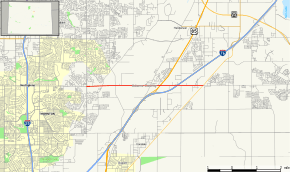 Map of Adams County in north central Colorado with SH 44 highlighted in red | ||||
| Route information | ||||
| Maintained by CDOT | ||||
| Length | 4.958 mi[1] (7.979 km) | |||
| Major junctions | ||||
| West end | Colorado Boulevard in Thornton | |||
| East end | ||||
| Location | ||||
| Counties | Adams | |||
| Highway system | ||||
Colorado State Highways
| ||||

Route description
SH 44 runs 5.0 miles (8.0 km), starting at a junction with SH 2, heading west across the South Platte River and ending at Colorado Boulevard in Thornton. The route west continues as 104th Avenue.
Major intersections
The entire route is in Adams County.
| Location | mi | km | Destinations | Notes | |
|---|---|---|---|---|---|
| Commerce City | 0.000 | 0.000 | Eastern terminus | ||
| 1.800 | 2.897 | ||||
| Thornton | 4.958 | 7.979 | Colorado Boulevard | Western terminus | |
| 1.000 mi = 1.609 km; 1.000 km = 0.621 mi | |||||
References
- "Segment list for SH 44". Retrieved January 21, 2011.
External links
This article is issued from Wikipedia. The text is licensed under Creative Commons - Attribution - Sharealike. Additional terms may apply for the media files.