Colorado State Highway 325
State Highway 325 (SH 325) is a highway connecting two state parks near Rifle, Colorado. SH 325's southern terminus is at SH 13 near Rifle, and the northern terminus is at Rifle Mountain Park.
| ||||
|---|---|---|---|---|
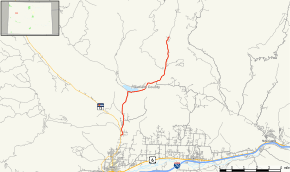 Map of Garfield County in western Colorado with SH 325 highlighted in red | ||||
| Route information | ||||
| Maintained by CDOT | ||||
| Length | 11.395 mi[1] (18.338 km) | |||
| Major junctions | ||||
| South end | ||||
| North end | Rifle Mountain Park | |||
| Location | ||||
| Counties | Garfield | |||
| Highway system | ||||
Colorado State Highways
| ||||

Route description
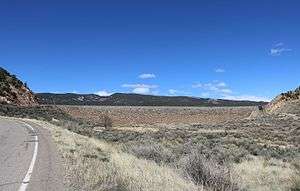
State Highway 325 by Rifle Gap Dam
SH 325 runs 11.4 miles (18.3 km), starting at a junction with SH 13 north of Rifle. The highway goes north to Rifle Gap State Park. From there it follows East Rifle Creek east and then north to Rifle Falls State Park. After passing the falls it continues north along the creek, ending at the entrance to Rifle Mountain Park.
Major intersections
The entire route is in Garfield County.
| Location | mi | km | Destinations | Notes | |
|---|---|---|---|---|---|
| | 0.000 | 0.000 | Southern terminus | ||
| | 11.395 | 18.338 | Rifle Mountain Park | Northern terminus | |
| 1.000 mi = 1.609 km; 1.000 km = 0.621 mi | |||||
See also
References
- "Segment list for SH 325". Retrieved 2011-01-22.
External links
This article is issued from Wikipedia. The text is licensed under Creative Commons - Attribution - Sharealike. Additional terms may apply for the media files.