Colorado State Highway 23
State Highway 23 (SH 23) is a 17.7 mi (28.5 km) long state highway in the northeastern corner of Colorado. The southern terminus is at U.S. Route 385 (US 385) in Holyoke, it then travels northeast through Amherst to its northern terminus at the Nebraska state line where it becomes Nebraska Highway 23 (N-23).
| ||||
|---|---|---|---|---|
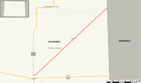 Map of northeastern Colorado with SH 23 highlighted in red | ||||
| Route information | ||||
| Maintained by CDOT | ||||
| Length | 17.7 mi[1] (28.5 km) | |||
| Major junctions | ||||
| South end | ||||
| North end | ||||
| Location | ||||
| Counties | Phillips, Sedgwick | |||
| Highway system | ||||
Colorado State Highways
| ||||
Route description
The route begins at US 385. After sixteen miles of crossing various roads without entering any incorporated cities, it exits Phillips County and enters Sedgwick County. About a mile later, it reaches the Colorado-Nebraska state line and becomes Nebraska Highway 23.
History
The route was formerly numbered as SH 176. However, it was changed to match the Nebraska highway number at its northeast end because both SH 176 and I-76 traversed through the same general region of the state.[2]
Major intersections
| County | Location | mi[1] | km | Destinations | Notes | |||
|---|---|---|---|---|---|---|---|---|
| Phillips | Holyoke | 0.000 | 0.000 | Southern terminus | ||||
| Sedgwick |
No major junctions | |||||||
| Perkins | Venango | 17.507 | 28.175 | Continuation into Nebraska | ||||
| 1.000 mi = 1.609 km; 1.000 km = 0.621 mi | ||||||||
References
- "Segment Descriptions for Highway 23". Colorado Department of Transportation. Retrieved 2008-03-26.
- Salek, Matthew E. (January 30, 2010). "Colorado Routes 20–39". Retrieved March 6, 2010.