Colorado State Highway 135
State Highway 135 (SH 135) is a 27.48-mile-long (44.22 km) state highway in the U.S. state of Colorado. SH 135's southern terminus is at U.S. Route 50 (US 50) in Gunnison, and the northern terminus is at 6th Street in Crested Butte. It is the primary connection between Crested Butte and the outside world and is the only paved road leading to Crested Butte.
| ||||
|---|---|---|---|---|
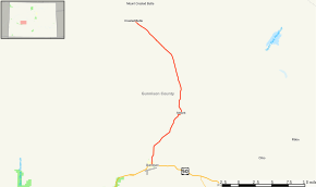 Map of Gunnison County in west central Colorado with SH 135 highlighted in red | ||||
| Route information | ||||
| Maintained by CDOT | ||||
| Length | 27.48 mi[1] (44.22 km) | |||
| Major junctions | ||||
| South end | ||||
| North end | 6th street in Crested Butte | |||
| Location | ||||
| Counties | Gunnison | |||
| Highway system | ||||
Colorado State Highways
| ||||

Route description
It begins at the intersection of U.S. Highway 50 and Main Street in Gunnison and follows Main Street North out of town. Between miles 10 and 11, it passes through the community of Almont. It terminates at the intersection of Elk Avenue and 6th Street (the Four Way Stop) in Crested Butte.[1]
History
The route was established in the 1920s, when it began at SH 92 in Hotchkiss and ended at Gunnison. The route was paved from its southern terminus to Paonia and from Almont to Gunnison by 1950. SH 135 was split in 1954 over Kebler Pass. The route was completely paved by 1958. A small section near Bardine was renumbered in 1970, leaving what is left today.[2]
Major intersections
The entire route is in Gunnison County.
| Location | mi[1] | km | Destinations | Notes | |
|---|---|---|---|---|---|
| Gunnison | 0.000 | 0.000 | Southern terminus | ||
| Crested Butte | 27.484 | 44.231 | 6th Street | Northern terminus | |
| 1.000 mi = 1.609 km; 1.000 km = 0.621 mi | |||||
References
- "Segment list for SH 135". Retrieved 2007-05-12.
- Salek, Matthew E. "Colorado Routes 120-139". Retrieved 2010-05-29.