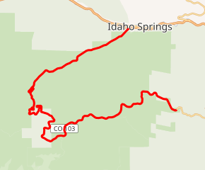
Colorado State Highway 103
State Highway 103 (SH 103) in the U.S. state of Colorado runs from Interstate 70 (I-70), U.S. Route 6 (US 6) and US 40 at Idaho Springs to county roads 151 and 103 at Squaw Pass. The 13 miles (19 km) from Idaho Springs to SH 5 forms about half of the Mount Evans Scenic Byway.
| ||||
|---|---|---|---|---|
SH 103 highlighted in red | ||||
| Route information | ||||
| Maintained by CDOT | ||||
| Length | 22.488 mi[1] (36.191 km) | |||
| Major junctions | ||||
| North end | ||||
| South end | CR 151 at Squaw Pass | |||
| Location | ||||
| Counties | Clear Creek | |||
| Highway system | ||||
Colorado State Highways
| ||||

Route description
The route begins at Idaho Springs, where it heads southwest away from the center of the city and follows the Chicago Creek. After exiting the city, the route begins climbing in elevation, ultimately reaching an elevation of about 10,000 feet,[2] where it meets SH 5, at Echo Lake Park. Together with SH 5, the route to this point forms the Mount Evans Scenic Byway,[3] the highest paved road in North America. Then the route continues through Squaw Pass, along the upper end of Echo Mountain Ski Area and on to its terminus at County Route 151. Past this point, the highway is not marked by CDOT, but the rest of what is called Squaw Pass Road descends toward Evergreen.
History
The route was established in 1923, where it began at US 285 and traversed to Idaho Springs. The segment east of Squaw Pass was renumbered in 1954, and the route was entirely paved by 1956.[2]
Gallery
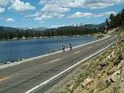 SH 103 at Echo Lake
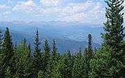 Looking northwest from near the summit of Squaw Pass
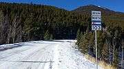 State Highway 103 near the southern terminus
Major intersections
The entire route is in Clear Creek County. [4][5]
| Location[4][5] | mi[4] | km | Destinations | Notes | |
|---|---|---|---|---|---|
| Squaw Pass | 22.488 | 36.191 | Little Bear Creek Road (CR 151) | Southern terminus; road continues east as Squaw Pass Road | |
| | 17.000– 15.717 | 27.359– 25.294 | Juniper Pass Summit – elevation 11,020 feet (3,360 m) | ||
| | 13.265 | 21.348 | Northern terminus of SH 5 | ||
| Idaho Springs | 0.000– 0.119 | 0.000– 0.192 | Northern terminus; I-70 exit 240; road continues as 13th Street | ||
| 1.000 mi = 1.609 km; 1.000 km = 0.621 mi | |||||
References
- "Segment list for SH 103". Retrieved 2007-05-12.
- Salek, Matthew E. "Colorado Routes 100-119". Retrieved 2010-05-09.
- "Driving Directions". America's Byways. Federal Highway Administration. Retrieved 5 August 2013.
- "Highway Data Explorer, Online Transportation Information System". Colorado Department of Transportation. Archived from the original on September 10, 2012. Retrieved October 2, 2016.
- "Highway Data Explorer, Online Transportation Information System". Colorado Department of Transportation. Archived from the original on 10 September 2012. Retrieved 15 October 2019.