Cloie Branch
Cloie Branch[1] (sometimes referred to as Cloie Creek[2]) is a 5.4-mile-long (8.7 km)[3] tributary of the Little Maquoketa River, rising in the northern part of the city of Asbury, in Dubuque County, Iowa.
| Cloie Branch Cloie Creek | |
|---|---|
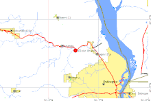 Cloie Branch (the red dot indicates the confluence between the creek and the Little Maquoketa River) (USGS) | |
| Location | |
| Country | US |
| State | Iowa |
| District | Dubuque County, Iowa |
| Physical characteristics | |
| Source | |
| • coordinates | 42.5069°N 90.7693°W |
| Mouth | Little Maquoketa River |
• coordinates | 42.5541°N 90.7462°W |
• elevation | 617 ft (188 m) |
| U.S. Geological Survey Geographic Names Information System: Cloie Branch | |
Burgeoning suburban development in the city of Asbury has encroached the upper reaches of the system. The northern end of the system is rural. Asbury's sewer outfall drains into the creek and mechanical failures have in the past lead to the discharge of only partially treated sewage.
See also
References
- U.S. Geological Survey Geographic Names Information System: Cloie Branch
- Iowa Water Archived 2012-02-07 at the Wayback Machine (retrieved 5 April 2007)
- U.S. Geological Survey. National Hydrography Dataset high-resolution flowline data. The National Map Archived 2012-03-29 at the Wayback Machine, accessed May 13, 2011
- Environmental Protection Agency (retrieved 5 April 2007)
- List of Dubuque County streams (retrieved 5 April 2007)
- Eileen Mozinski, "Riniker: I was not notified of wastewater release", Dubuque, Iowa Telegraph Herald, 5 April 2007, p. 1 (online version, registration required)
This article is issued from Wikipedia. The text is licensed under Creative Commons - Attribution - Sharealike. Additional terms may apply for the media files.